

The unique water bodies of Bundelkhand
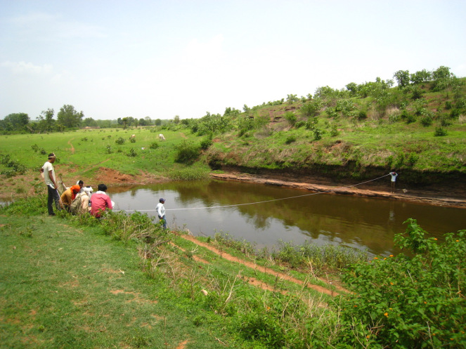
Many bharkas/kunds -- naturally occurring ponds within a river bed -- are common in almost all the villages of the upper catchment of the Ken river, one of the major rivers in the region
Kathayi (Shahnagar, Panna district), a Scheduled Tribe-dominated village with 75 households, situated amid the forested area of Shahnagar block, faces acute water scarcity during summers — almost for 3-4 months. Under the government schemes, three wells and two hand pumps were installed in the last 10-15 years, but most of them are dysfunctional.
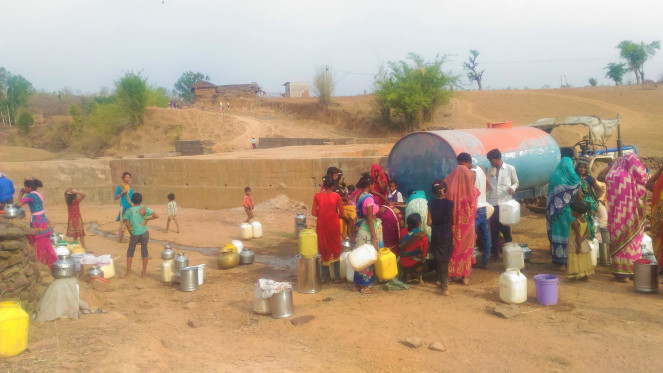
The problem becomes acute in the months of May-June when there is a shortage of water everywhere, and only perennial spring in the village supplies drinking water to the 75 families. Women have to spend the whole night queueing up to fetch water. After a lot of perusal, a water tanker was provided by the gram panchayat, but the supply is intermittent.
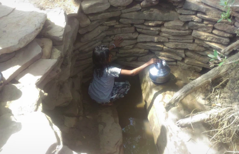
The first impression was that the groundwater potential seemed to be very low in the region looking at the status of wells and handpumps. But detailed investigation shows that it is not the case. The villagers say that there was one perennial bharka — a naturally occurring ponds within the river bed — at the Puttan Ghat within the river bed, which was almost 200 meter-long, and two-meter deep.
According to a farmer from Kathayi, Ujiyar Singh: “The villagers never faced water scarcity until the government placed a stop dam downstream of the bharka in 2001-02, even though villagers resented the construction. No measures were taken to avoid the siltation behind the stop dam and eventually, the bharka was completely filled with debris and silt within 5-6 years of the construction.” Some of the base flows (jhir in the local language) in the downstream of this bharka started disappearing over the years as silt started accumulating in the bharka.
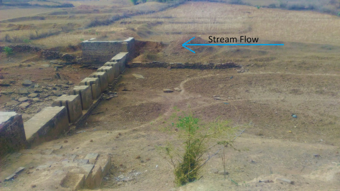
Bharkas are alive elsewhere
The Bharka disappeared in the village of Kathayi due to bad planning, but they are still alive and perennial resources in the numerous villages in the Shahnagar block. The villagers of Aloni (Shahnagar block, Panna) seek 1-2 life- saving irrigation for wheat crop in 10-15 ha of land from one such perennial bharka (also called as Kund in the local dialect) called as “Panghata Kund”, which is approximately 200-meter-long, 1.5 meters deep and 20 meters in width. The other two such Kunds along the Baghne Nala are used by the villagers for domestic needs in the peak summer. The narration by villagers confirms that these bharka/kunds are in use since ages. They say: “The kund has been in use for more than 300 years now when the ancestors settled down here. They would have settled because of the presence of this natural resource. Where there is water, there is life”.
Such bharka/kund are common sites in almost all the villages of the upper catchment of the Ken river. The Ken river is bestowed with various geological and geomorphological marvels like deep cavities and narrow rocky channel at the Pandvan fall, beautiful canyon formation at the Raneh fall, the Dhuvadhar Seha (fall) in the Panna Tiger Reserve where the river plunges from one plateau to another, the Doline (a geological formation of deep cavities) formation like Brihaspati Kund, Suryakund etc.
The uniqueness of these features are documented by Prof Brij Gopal ji (the member of the IPCC committee and retired professor from JNU), notable river activist M Manoj Mishra (Yamuna Jiye Abhiyan), SANDRP and a few more notable publications. But most of these geological marvels are found in the middle stretch of the Ken river. There is no documentation on the geological features in the upper catchment of the river. These bharka/Kunds (and springs) are important as they supply drinking water to the populace as well as life-saving irrigation to hundreds of acres of land.
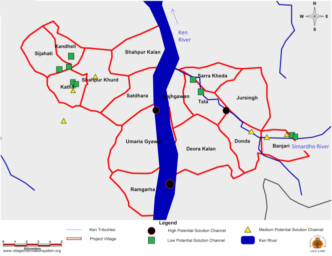
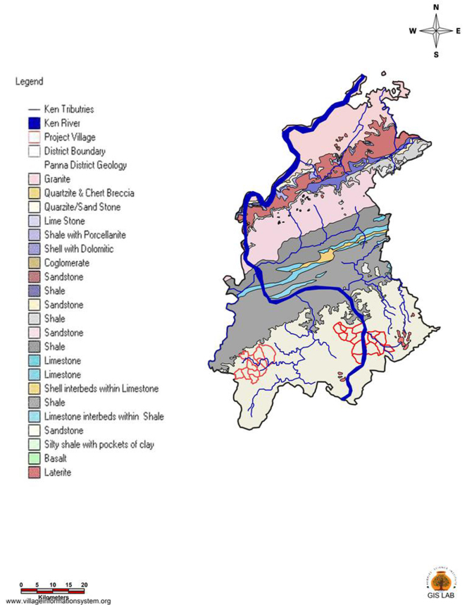
They play an important role in achieving water security in the otherwise parched and distressed region. I am not a geologist to understand the exact geological formation and complex underlying hydro-geology, but this article is a first attempt to document these geological features, their groundwater potential, traditional wisdom to conserve them, etc. The article is based on observations from 26 villages in the Upper catchment of the Ken river in the Shahnagar block of Panna district (location in Map 1).
Geology
According to the groundwater expert Dr Himanshu Kulkarni (ACWADAM, Pune): “At the first impression, the bharka/kund looks like nothing but a large spring – a groundwater discharge point. The southern plateau of Bundelkhand is called the Vindhyan range and this is broadly characterised by sandstone, shale and limestone. The huge cavities must have formed due to the erosion of limestone over the geological period due to the base flows. More details can be curtailed only if the hydro-geological study is conducted by taking measures like pumping test etc.”
The topography of Panna district is mostly hilly and traversed by hills and valleys. Physiographically, the Panna district forms the parts of Vindhyachal ranges in the south followed by Bundelkhand upland in the north. The Southern plateau is formed by the cascade type rocks of the Vindhyan series. The Vindhyans are composed of sandstone, shale, and limestone.
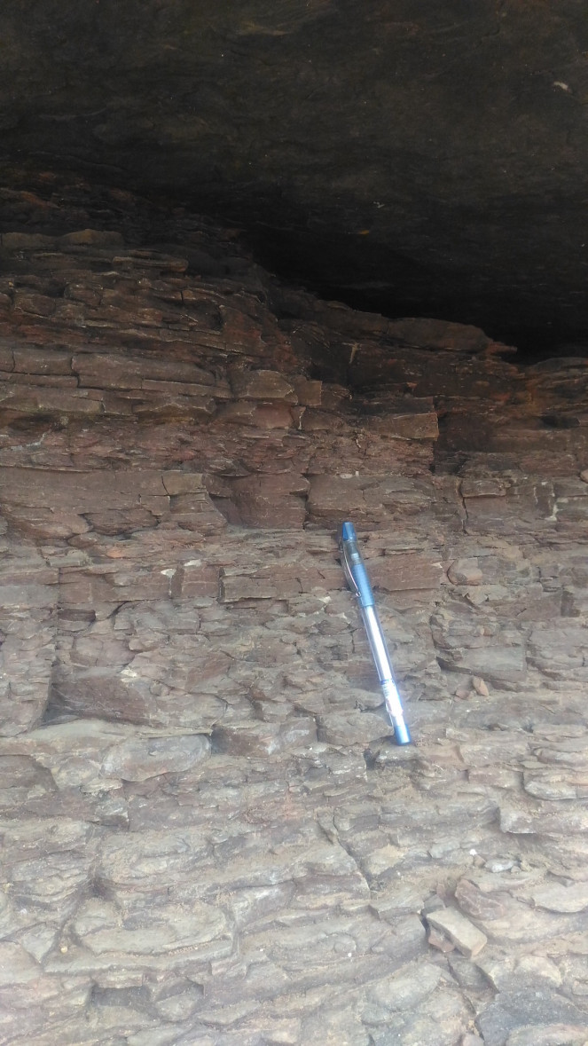
As per the study done by the People’s Science Institute, the study area is underlined by quartzatic (a quartzite is a metamorphic rock formed when quartz-rich sandstone or chert has been exposed to high temperatures and pressures) formation and beds are generally horizontal.
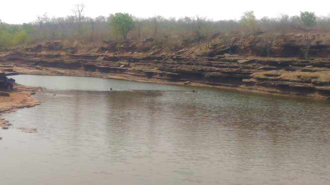
A network of joints, fault planes, bedding planes, weathered, fractured and saturated fractured zones which act as a secondary porosity and forms the aquifer system. In general, the quartzite are thought to be resistant. However, the presence of small amounts of pyrite in the quartzite make them vulnerable to weathering. This explains the horizontal bedding and vertical fractures as seen in the images of the Kund, and these structural features are mainly responsible to maintain the hydraulic continuity within the aquifer system.
The presence of limestone in this geology has given rise to large solution cavities. The CGWB’s (Central Ground Water Board) district groundwater profile confirms that there is only one limestone layer which is called as the Nagod limestone and solution cavities in limestone formation create the potential aquifer. Fractured/weathered rocks and bedding planes discharge the groundwater into these solution cavities. This explains the formation of the bharka/kund, thus the complexity of hydro-geology.
The groundwater potential
The PSI conducted the initial assessment in 26 villages of the Shahnagar block. The assessment is based on the usage of the water to quantify and extrapolate the potential based on usage. (Limitation: The real assessment of the groundwater potential can be known only after a hydro-geological study and the calculation of groundwater yield by pumping tests).
There are two clusters in the study area – Cluster one consists of 11 villages along the Baghne river, a tributary of the Patne river in the Raipura Tehsil of Shahnagar, whereas the second cluster is of 15 villages in Shahnagar Tehsil, which are along the Ken river and the Simardha river, a tributary of the Ken river as shown in the map.
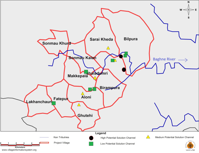
The solution cavities are categorized into three types based on the usage:
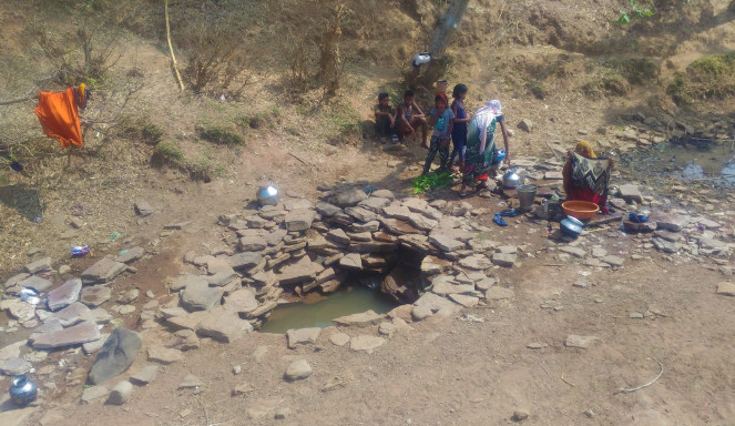
Low potential solution channels: These are approximately 50 meter-long, up to one-meter in depth, and the width equals to the water stream’s width (approximately 3-5 meters). They are generally used for domestic purposes and are kept reserved for livestock during peak summer.
Medium potential solution channel: The average size is, length 100-300 meters, depth 2-3 meters, and the width equal to the water stream (approximately 5-7 meters). They are used to irrigate land up to 10-15 ha, seeking 1-2 life-saving irrigations.
High potential solution channel: They may vary in the length from 300 meter to a few kilometres and can irrigate the land up to 50-100 ha, seeking 2-3 irrigations.
The study area is inhabited by 3,600 families with a total population of 15,532 as per the census of 2011. The area is dominated by a tribe called the Raj Gaur (the ruling clan of the Gond tribe). In the region, a family owns average 4-5 cattle (big ruminants). Based on secondary data, primary data collected from the villages, and focus group discussion with the villagers, the total water usage in these villages has been calculated.
The total annual water usage from the solution cavities is almost 17 lakhs cum (cubic meters) (16 lakhs cum for irrigation and 1 lakh cum for drinking (human as well as livestock) and domestic needs). If the data is extrapolated to the entire Shahnagar block, the total usage is approximately 20 Mcum, which is 2% of the total rainfall received in the entire region (the total geographical area of Shahnagar block is 1052 SqKm and the average annual rainfall is 1,000 mm (the net annual groundwater availability in Shahnagar block is 109 Mcum as per the assessment in 2008-09. Source: District Groundwater Information Booklet – Panna District, CGWB) and 20% of the net annual groundwater availability in Shahnagar block.
This is indicative of the huge groundwater potential of bharka/kund in the upper catchment of the Ken river, which drains out of the Vindhyan range travelling through some of the blocks of Damoh, Sagar, Chhatarpur and Panna districts.
Governance
Like the springs all over India, these solution cavities and springs in this region are missing from the map of the CGWB. Hence, the only governance is traditional beliefs and customs. According to Ganesh Singh Gaur of Banjari village: “Raja kund is named after Gond Raja who used to bathe here. The gods reside in the Raja Kund at a certain depth. If the water level goes below that and gods are exposed to air, this is a sure indicator of drought and famine. In 2017, people over-exploited the Kund and the next year we have seen the worst of drought, cattle deaths, lack of drinking water etc. Hence since the last two years, the villagers are not using it for wheat irrigation. Rather, the water is left as a stock for livestock and wild animals.”
Similar beliefs are in place in the Siharan village of Raipura Tehsil. According to villagers, a temple named “Shivpuri” was constructed next to the Kund almost 100-200 years ago by the ancestors as a statue of the deity was found in the Kund. Almost 15-20 villages around this place maintain the sanctity of the place, the Shivpuri Kund is treated as sacred, and nobody is allowed to fetch water from the Shivpuri Kund except for the freely grazing animals.
The way forward
Bundelkhand has become a synonym for drought and distressed as the region is facing the worst of meteorological and/or agriculture droughts for more than a decade now. Apart from the crippled agrarian economy, mass migration, malnutrition, starvation death, mortgaging of cattle, child, women etc, “the desertification of villages” in the search of drinking water had hit the media last year.
Moreover, climate change is exacerbating the distress. Hence holistic planning of the water resources in the region is necessary. There is abundant literature available on Bundelkhand’s water resources, but it mainly focuses on the surface water and there is less documentation on the groundwater. The CGWB and the MPWRD’s assessments for groundwater are available and as per these reports, groundwater resources are more depleted in the plain – the northern region of the Bundelkhand as compare to southern hilly terrain. These assessments are based on observatory wells and bore-wells; the density of which is very low in the hilly terrain of Panna, Damoh, Sagar and Chhatarpur districts of Bundelkhand.
The MPWRD (Madhya Pradesh Water Resources Department) assessment on groundwater recharge excludes the hilly terrain with slope more than 20%. Due to the lack of documentation on springs and bharkas in the CGWB and the MPWRD’s groundwater resources assessment studies, there is no complete assessment of groundwater in the upper catchment of the Ken river.
Moreover, wrong interventions around these formations can destroy the vital resources as was the case of Kathayi. Other policies like the power rationing for agriculture purpose too interferes with the groundwater use. Mithla Yadav from Saraikheda village reported that “since the installation of the electricity connection for agriculture and a fixed rate of pumping cost, villagers have pumped an enormous amount of water from these Kunds leaving them dry at times. This has led to a severe drinking water crisis in 2018-19 despite average rainfall”.
The groundwater potential varies across the region owing to the diversity in the geology and hydrogeology. Hence, “one-size-fit-for-all” state policies would not help in mitigating the current water crisis. For the holistic water management, knowledge of groundwater is essential along with rainwater and surface water. The unique groundwater resources of the upper Ken need acknowledgement, research and further assessments by the groundwater departments. The groundwater dynamics of the region and it’s potential in achieving water security in the region is a topic for further investigation and documentation.
The government has a plan to supply drinking water to 180 villages of Shahnagar block from the recently-constructed TenduGhat dam. Whether the scheme will achieve the drinking water security or not, but certainly low-cost conservation of these bharka/Kund can serve the purpose of at least ensuring drinking water security.
This guest blog by Seema Ravandale (People’s Science Institute, Dehradun) has been sourced from SANDRP. You can read the original blog here.