

Uttarakhand Disaster: Glacier burst may not be the cause, but the Hindu Kush Himalayan region’s glaciers, which support over 1.3 billion people, are under threat
Union home minister Amit Shah told the Rajya Sabha today that a landslide led to the flash floods in Chamoli. Meanwhile, scientists are trying to ascertain the exact cause. Worryingly, a number of glaciers in the Hindu Kush Himalayan region are receding. Ten of Asia’s largest rivers originate in the region sustaining over a billion people.

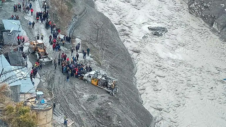
Pic: Rajeev Ranjan Deo Pandey/Twitter
Today, Union home minister Amit Shah made a statement on the Uttarakhand disaster in the Rajya Sabha. While initial reports pointed towards a glacier burst that triggered flash floods in Joshimath area of Chamoli district, Shah pinned the blame on a landslide of about 14 square kilometres, at an altitude 5,600 metres above mean sea level, near a glacier.
“The landslide led to flash floods in the Rishiganga river, whose water rose manifold, and washed away two small hydro power projects. In Tapovan, an under-construction 520 mega watt power project of NTPC has also suffered damage,” Shah informed the Rajya Sabha.
He added that 25 to 30 people are still feared stuck inside an NTPC tunnel, and rescue operations are underway on a war footing. Because of the collapse of a bridge, 13 villages have been cut-off, and essentials are being air-dropped.
Massive flash floods in Rishiganga river which flows into the Dhauliganga river, a tributary of the Alaknanda (which later forms the Ganga), have caused mayhem. Till 8 pm on February 8, at least 26 dead bodies had been recovered from Tapovan, while 171 people are still missing. The Indo Tibetan Border Police (ITBP) and National Disaster Response Force (NDRF) are working against time to rescue people. However, with the passage of time, hope is dwindling.
Initially, it was believed that a glacier burst inside the Nanda Devi Biosphere Reserve had led to an avalanche and flash floods. However, state chief minister Trivendra Singh Rawat also said the “accumulation of snow during the past few days triggered a landslide, which brought debris and water with force.” Meanwhile, a team of glaciologists from the Wadia Institute of Himalayan Geology, Dehradun, is at the disaster site to study the possible causes.
A statement issued by the GB Pant Institute of Himalayan Environment and Development, Almora, Uttarakhand, said the institute’s faculty “is visiting the site for survey and to get science-based evidence”. It said it would be premature to make any statement till “the team completes its survey and submits a report”.
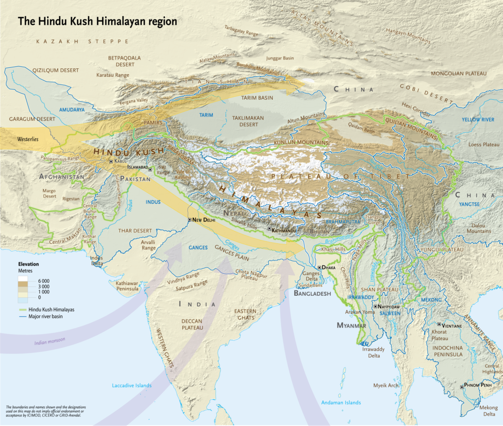
Glaciers in the Hindu Kush Himalayas
The Hindu Kush Himalayas stretch over 3,500 kilometres across eight countries — Afghanistan, Bangladesh, Bhutan, China, India, Nepal, Myanmar and Pakistan — and are also known as the ‘water tower’ of the world. They are the source of 10 of Asia’s largest rivers as well as the largest volume of ice and snow outside of the Arctic and Antarctica.
Together, these rivers support the drinking water, irrigation, energy, industry and sanitation needs of 1.3 billion people living in the mountains and downstream.
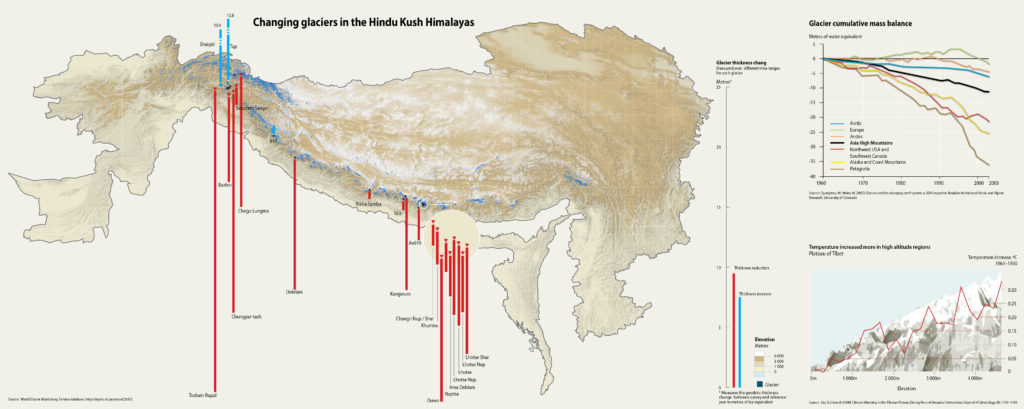
A number of research studies have documented how, since the mid-19th century, most Himalayan glaciers have both retreated and lost mass, with some exceptions in the Karakoram and northwestern Himalayas. Most models project substantial glacial mass and area losses in the coming decades for most parts of the Hindu Kush Himalayas.
“The Himalayas are a water tower. With increasing global warming, the upper reaches are warming faster, leading to more rapid melting of the glaciers,” said A P Dimri, professor, School of Environmental Science, Jawaharlal Nehru University, Delhi.
At the upper river basin scale, the Indus, Brahmaputra, Ganges, Salween and Mekong are projected to lose considerable glacial area by 2050, notes GRID-Arendal, a non-profit environmental communications centre based in Norway. For the Indus basin, a change in glacier extent ranging from minus 20 per cent to minus 28 per cent is projected.
Changes in glacier area in the Ganges and Brahmaputra basins show similar trends (minus 35 per cent to minus 45 per cent). It is claimed that even if today’s level of emissions are greatly reduced, glaciers within the Everest region (Dudh Koshi basin, Nepal) are projected to lose between, on average, 39 per cent of their ice by 2050 and around 83 per cent by 2100.
A major contributor towards this loss is going to be temperature increase and global warming. As temperatures rise, more glaciated areas will be exposed to above-zero temperatures. This will cause glaciers to melt. Also, more precipitation will fall as rain rather than snow, resulting in melting ice not being replenished.
Rising temperatures, decreasing snowfall
Already, a large number of communities living in the Indian Himalayan region are complaining of rising heat and decrease in winter snowfall. Manikaran in Parvati Valley of Himachal Pradesh is located at an altitude of 1,760 metres (5,774 feet) above mean sea level. As per local people, the impact of climate change is clearly visible in this town, famous for Gurudwara Shri Manikaran Sahib.
“Earlier, winters would begin in November and last till February. Now, we experience the first snowfall only in December,” Karan Singh, sahayak prabhandhak (assistant administrator) at the gurudwara told Gaon Connection.
According to him, the snowfall pattern has changed, too. “During my grandfather’s time, there used to be four to five feet of snowfall in Manikaran. Now, we barely receive four to six inches [0.3-0.5 feet],” he informed. Gurdwara authorities have installed ceiling fans for pilgrims in the last two years, a clear sign of rising temperatures.
According to S S Randhawa, principal scientific advisor, State Centre on Climate Change, Shimla, Himachal Pradesh, between 1962 and 2001, there has been an overall reduction in glacier area from 2,077 square kilometre (sq km) to 1,628 sq km in the state’s Chenab, Parvati and Baspa basins.
The Chota Sigri glacier retreated by 6.81 metres per year between 1962 and 1995. Bara Sigri retreated by 29.78 metres per year between 1906 and 1957, while Beas Kind glacier has retreated by 18.8 metres per year between 1963 and 2003.
In Kullu district of Himachal, the area of glaciers has reduced from 544.62 sq km in 2002 to 489.12 sq km in 2006.
Also Read: Climate change hits Himachal’s famous apples, causes the of frequent floods
Little wonder, after the Uttarakhand disaster, villagers in Lahaul and Spiti district of Himachal have upped their protests against the proposed hydropower projects in the ChandraBhaga river basin. They fear blasting and tunnelling their hills to construct dams will destroy their rivers and mountains, and increase the risk of disasters.
“Planning and implementing large engineering projects on Himalayan rivers is fraught with great risks. Scholars have been warning about these for decades, but the EIA [environment impact assessment] for these projects withhold or underplay this information so that projects get approved,” said Manu Menon, senior fellow, Centre for Policy Research, New Delhi.
“Given that climate change is such a complex phenomenon and is affecting everything in our environment, development and environmental policies should really not select options that put people at great risk, she added.
What do experts say?
“The unfortunate event in Uttarakhand yesterday reveals once again the fragility and the inherent hazard characteristics of the Hindu Kush Himalayas,” said Arun B Shrestha, regional programme manager, Transboundary River Basins and Cryosphere, ICIMOD, Kathmandu. “Science has already shown that disasters like the one seen in Uttarakhand is something we have to better prepare for, as the probability of such events happening in the future increases with the ongoing rate of climate change and socioeconomic changes,” he added.
According to Dimri, the rapid melting of glaciers has resulted in increased glacier lakes, formed by water melting from the ice caps and accumulating at the mouth or snout of the glacier. These lakes also become reservoirs of ice and moraine debris. “With an increase in this phenomenon, the breach of glacier lakes poses a severe threat to communities living downstream,” he added.
Mohd Farooq Azam, assistant professor, Glaciology & Hydrology, Indian Institute of Technology (IIT) Indore said that although it is hard to fully ascertain the source of the water and slurry seen in the videos of the Uttarakhand disaster, “the current hypothesis is that the water accumulated and locked in the debris-snow below the glacier was released when the glacier-rock mass fell, dropping almost two kilometres before hitting this marshy land”.
“However, we need more data from the field as well as satellites to conclude the reason with some confidence. It may take a few days,” he added.
Meanwhile, Shrestha said it was imperative to “work together, with urgency, to better understand and prepare for such events at the local, national and regional levels. This will be important, not just for the lives and livelihoods of people in the mountains but also for millions living downstream”.