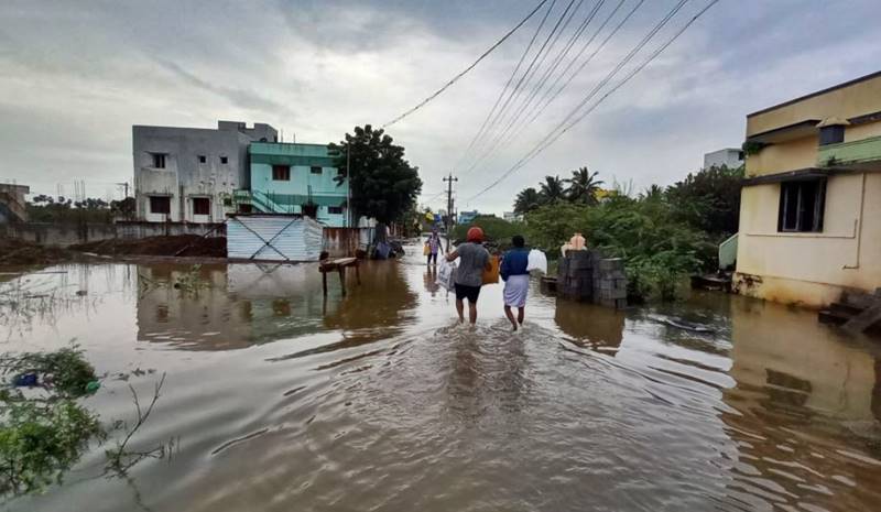
Heavy rainfall in Tamil Nadu has thrown life out of gear in several parts of the state and at least 12 people have lost their lives due to rain-related incidents. A red alert has also been issued for Tamil Nadu and Puducherry while parts of Kerala have witnessed inundation as well.
The primary reason for the heavy rainfall in the southern states is the formation of a depression in the Bay of Bengal which is gradually moving towards Tamil Nadu.
The southern part of the country witnesses rains twice a year as both southwest and the northeast monsoon cycles shower the region first in June and then towards the winters.
But the rainfall is proving to be extraordinarily high in the current season. Tamil Nadu has rain excess of 45 per cent , with actual rains of 361 millimetres (mm) against the normal of 248.3 mm from October 1 to November 9. It is reported that 13 teams of National Disaster Response Force (NDRF), including five teams in Chennai, have been deployed in Tamil Nadu and Puducherry for rescue and relief operations. Also, three teams have been kept on stand by position for additional support in the flood relief operations.
Chennai floating on water!
— Pradeep Kumar ❁ (@CMPradeepkumar_) November 8, 2021
Many districts in Tamil Nadu are flooded due to heavy rains. With this in mind, the National Disaster Rescue Team should be on high alert throughout Tamil Nadu.#ChennaiRains #flooding #TamilNaduRains #RedAlert pic.twitter.com/iskrs2D4AX
Connectivity has been hampered by the heavy rainfall across southern parts of the country as several areas in Tamil Nadu and Kerala have been affected by waterlogging and inundation. Tamil Nadu Chief Minister MK Stalin travelled to flood-hit areas in the state and oversaw the relief measures. “People who are travelling back to Chennai after Diwali holidays are advised to postpone their trip by two days due to heavy rains,” he said while interacting with the Press.
Here’s what causing heavy rains in southern India
According to a briefing prepared by the Climate Trends — a Delhi-based strategic communications company, three weather phenomena have come together and are resulting in massive precipitation in the region. These three phenomena are La Nina, Indian Ocean Dipole (IOD), and Madden-Julian Oscillation (MJO).
The Madden-Julian Oscillation (MJO) is a weather phenomenon which causes a major fluctuation in tropical weather on weekly to monthly timescales. The MJO can be characterised as an eastward movement of cloud and rainfall near the equator that typically recurs every 30 to 60 days.
Also, La Nina is expected to continue with an 85 per cent chance in December 2021- February 2022.
La Nina is observed when the water temperature in the eastern part of the Pacific gets comparatively colder than normal due to which there is a strong high pressure over the eastern equatorial Pacific. The difference in pressure between Eastern Pacific and Western Pacific/Asia causes a moisture-laden wind movement from East to West Pacific and Asia.
According to the meteorologists, La Nina is invariably linked with good northeast monsoon rains during the latter half of the monsoon.
The briefing by the Climate Trends mentions that the IOD event is still persisting and the presence of IOD is favourable for good rains over the Indian mainland.
The IOD is actually an irregular oscillation of sea surface temperatures in which the western Indian Ocean region becomes comparatively warmer and then colder than the eastern part of the ocean. The temperature difference causes movement of moisture-laden winds which pass through peninsular India.
Climate change a contributing factor?
The meteorologists are of the opinion that the contribution of climate change cannot be ruled out as a reason behind the torrential rain in the region.
Roxy Mathew Koll, a climate scientist at the Pune-based Indian Institute of Tropical Meteorology was quoted, “The Indian Ocean is getting warmer at a faster rate than any other ocean in the world due to greenhouse gases. Although the rate of warming is more in Arabian Sea than Bay Bengal, the rise of a degree or two in oceanic temperatures can have a large impact”.
Also Read: 80% Indians live in climate-vulnerable districts: Study
In view of IMD alert of continuing/ impending heavy rains in Southern states esp Tamil Nadu,AP & Kerala, several teams of @NDRFHQ either pre-deployed or on ready standby.#Committed2ServeIndia🙏🏻🇮🇳🙏🏻 @HMOIndia @BhallaAjay26 @PIBHomeAffairs @pibchennai @ANI @PTI_News pic.twitter.com/PCqhOzRRjT
— ѕαtчα prαdhαnसत्य नारायण प्रधान ସତ୍ୟ ପ୍ରଧାନ (@satyaprad1) November 9, 2021
“One aspect of climate change that is important for the east coast including Tamil Nadu is that extreme weather and climate events are overlapping. Now, we know that sea level is rising in the background. Hence, the flood level due to storm surge and rains are rising year on year,” he added.
Echoing Koll’s remarks, Mrutyunjay Mohapatra, Director General of Meteorology in the India Meteorological Department said, “Climate change has led to an increase in sea surface temperatures that in turn has resulted in sea level rise by 10-%15%,”.
“Further, it is an established fact that global warming has increased the frequency of heavy rains, even if it is associated with a low-pressure area,” he added.
Also Read: Massive floods in October catch villagers in UP’s Barabanki by surprise


