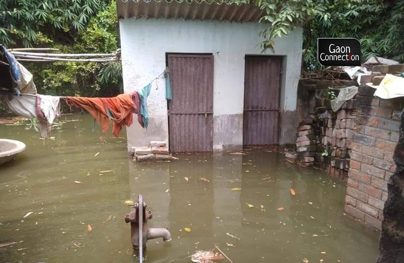
On the eve of India’s 75th independence day, while the country was preparing to celebrate its freedom, residents of Ramdiri village in Begusarai district were running helter-skelter. As floodwater of the Ganges entered their village and their homes, panic ensued. For the flood-hit villagers, it was a fight against time to rescue family members and cattle, and rush to a higher ground.
“We were all about to call it a day and sleep. We all, especially the kids, were filled with josh as it was the eve of swantantrata diwas,” Jai Prakash Singh, a resident of Ramdiri, narrated to Gaon Connection. “However, in no time we found ourselves rushing to save our lives. Villagers ran amok to protect their cattle. Floodwater had entered our houses creating extremely unhygienic conditions. We barely slept that night,” 66-year-old farmer said.
His 20 acre (about eight hectares) farmland, which had ripe crops of chillies, pumpkins, gourd and tomatoes, was inundated and the entire produce was lost. “My field has been flooded with water for over five days. No vegetable crop can survive that. One should be glad if one is alive with no significant harm to their loved ones. Survival is the only thing that matters right now, monetary gains can be made later,” he told Gaon Connection.
Since the arrival of the monsoon in June this year, Bihar has been facing an onslaught of floods. From the border districts of India-Nepal border in north Bihar, which faced inundation in June and July months, the floods have now spread to several districts in south Bihar, which is a predominantly drought prone region.
As per the official flood data of August 20, at least 2,570 villages in 15 districts of the state are facing floods that have affected a population of 3.74 million. The state government has set up 75 flood relief camps. Of the 15 flood-hit districts, five — Patna, Bhojpur, Lakhisarai, Bhagalpur and Munger — are in south Bihar, which is predominantly a drought-prone area.
बाढ़ प्रभावित क्षेत्रों का हवाई सर्वेक्षण किया एवं कटिहार जिले के बरारी प्रखंड में बाढ़ राहत शिविर का निरीक्षण कर आवश्यक निर्देश दिया। https://t.co/ZKy7IcyMbU pic.twitter.com/DVKWQkzxhZ
— Nitish Kumar (@NitishKumar) August 18, 2021
Apart from Bihar, the neighbouring state of Uttar Pradesh, and also Madhya Pradesh has been dealing with massive floods, as reported by Gaon Connection in the past ten days.
Floods in parts of south Bihar
Bihar is India’s most flood-prone state; 28 out of its 38 districts are flood-prone, according to the Water Resource Department (WRD) of the state government
Geographically, more than 73 per cent of Bihar’s 94,163 square kilometre area is flood-prone. The problem is particularly acute in north Bihar, where almost 76 per cent of the population — about 50 million people — lives under the constant threat of floods.
While north Bihar is known to face recurring floods, districts in south Bihar are predominantly drought-prone. It is only when Ganga river faces massive floods that it inundates the south Bihar districts along its course. And the river is in full spate right now and has marooned several villages in south Bihar.
“The floods in Bihar this year are not usual and are intensified due to three things in general — high rainfall in the states of Rajasthan, Madhya Pradesh and Uttar Pradesh; unsustainable development activity in the hills of Uttarakhand; and the infamous Farakka dam in West Bengal,” Patna-based flood expert Ranjeev told Gaon Connection. He has been studying floods in the state for the past four decades now.
Talking about each factor, the flood expert said, “It is obvious that the high rainfall in the neighbouring states increases the volume of water in the downstream areas [Bihar] as several rivers in the states flow into Ganga, which then enters Bihar.” A flood in Uttar Pradesh will have an impact downstream as within a week or so, districts in Bihar begin to witness higher levels of water in the Ganga river, he explained.
Secondly, he pointed towards the infrastructure projects in Uttarakhand and the deforestation. “A small change in the ecology of the hill states like Uttarakhand translates into an enormous crisis in the plains when the rivers bring along the silt,” he said. This monsoon season, Uttarakhand has witnessed several landslides and cloudburst events.
Also Read: Kinnaur landslide: Villagers up the ante in the battle against hydropower projects
“Reckless construction often adds to the debris in the rivers and the amount of silt brought along gets deposited in the plains which often disrupts the flow of rivers and intensifies the floods in the floodplains of Bihar. Flooding in a floodplain is a natural phenomenon but the destruction to life and property is a result of human intervention,” Ranjeev asserted.
Lastly, the flood expert pointed out the Farakka dam in West Bengal’s Murshidabad, which, according to him, worsened the flood situation in Bihar. “The Farakka dam obstructs the natural flow of the river and Bihar has to suffer when the volume of water goes up in the rivers and its backwater expands,” he said.
A week back, on August 14, South Asia Network on Dams, Rivers and People (SANDRP) — a Delhi-based organisation that carries out research on the river systems — wrote an article, ‘Why are Patna & Bhagalpur facing unprecedented floods on India’s 75th independence day?’, which stated that despite Bihar Chief Minister Nitish Kumar repeatedly stating that the Farakka dam acts as a ‘bottleneck’ and increases the incidence of floods in Ganga, the government has not done much to address it.
“This has led to huge drainage congestion along the river, reducing the carrying capacity of the river massively. It is this then which does not allow the quick drainage of the flood peak, a problem that the river upstream from what we can call Farakka Influence Zone (FIZ) does not face, but the river flow starts slowing down in FIZ,” it stated.
Poor, landless farmers suffer the most
Pradip Vidrohi, a resident of Bhagalpur district told Gaon Connection that the state’s compensation for the crop damage due to floods is hijacked by the landowners but the poor landless farmers who toil on the land get nothing.
“The compensation is provided to those who own the land but it’s not distributed to landless farmers who take land on rent for farming or practice share cropping. The rich landowners have the means to compensate for their losses, they get their names registered for compensation but the poor, landless farmers get nothing,” Vidrohi said.
“Small farmers do not have the pump sets to flush out the water from their fields that remain waterlogged for several days or sometimes weeks,” he added.
Meanwhile, it is the third month of the monsoon season and several districts of Bihar continue to remain flood-hit. Flood-affected villages are facing acute shortage of safe drinking water and food. There are fears of outbreak of diseases too.
“The toilets overflow. Poor people have no water to drink despite their households being flooded with dirty water. Excreta and other wastes float in the flood water and all this results in deterioration of the people’s health. Children and old people fall sick. Diarrhoea and stomach infection are pervasive during the floods here,” Rahul Kumar, the 40-year-old resident of Ramdiri village in Begusarai, told Gaon Connection.


