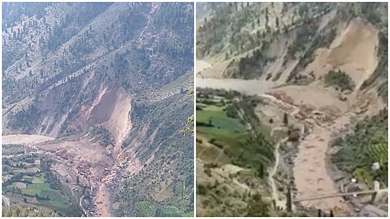
At around 9 am on August 14, some 200 villagers of Jasrath village in Lahaul and Spiti district in Himachal Pradesh began to run helter skelter. A massive landslide near their village had blocked the flow of the Chenab river leading to formation of an artificial dam about 500 metres away. There were fears of the river submerging the village or causing flash floods as and when the dam breached.
Sudarshan Jaspa, the village councillor, promptly alerted the district authorities about the incident and asked for immediate help minutes after the landslide.
A #landslide occured in Lahaul and Spiti district and the debris blocked the flow of #Chenab river
— Raj Bhagat P #Mapper4Life (@rajbhagatt) August 14, 2021
Illustration drawn on Google Earth shows debris & barrier lake that has formed upstream. There are few villages downstream -evacuated but some bridges could be lost if lake bursts pic.twitter.com/Svi9sK5rEt
“The threat of being inundated by the Chandrabhaga (local name for Chenab) river’s water was very real as the water was being deposited around the debris which contained tonnes of rocks and boulders,” Jaspa told Gaon Connection.
Villagers said they were reminded of the Chamoli tragedy in February this year when an avalanche led to a major disaster in Uttarakhand.
Also Read: Rock and ice avalanche caused Feb 2021 Chamoli, Uttarakhand disaster, explains scientific study
“However, we were lucky. The river slowly made its way through the debris within three hours and now normalcy has returned to our lives,” said a relieved Jaspa. “The villagers quickly crossed over the nearby bridge to reach the other side, otherwise the bridge might have broken due to heavy flow of the river. It was an anxious moment for all of us but it got resolved,” he added.
“Four houses in the nearby Talang village got submerged due to the disruption in river’s flow. Had the water stayed deposited for another hour, 15-20 houses must have been submerged,” Vikram Katoch, a Himachal Pradesh-based climate activist from Lahaul Spiti Ekta Manch, told Gaon Connection.
UPDATE: हिमाचल प्रदेश के लाहौल स्पीति ज़िले में चन्द्रभागा नदी के जल प्रवाह में आया अवरोध खत्म; आसपास के गांवों में बाढ़ का ख़तरा टला#HimachalPradesh pic.twitter.com/Vao2iaIe4P
— डीडी न्यूज़ (@DDNewsHindi) August 13, 2021
Although a major disaster has been averted, there is tension in the air as this monsoon season, heavy rainfall has caused multiple landslides in the Himalayan region states including Himachal Pradesh.
“The lithology (the study of the general physical characteristics of rocks) in the Lahaul Spiti area is fragile. The slope angle of the mountains here is sharp. It is well known that the Himalayas are tectonically very active. When you have these conditions, the increase in rainfall in the area can prove to be destructive,” Ambrish Kumar Mahajan, a geologist told Gaon Connection. He is a professor at the School of Earth and Environmental Sciences in the Central University of Himachal Pradesh.
Also Read: Kinnaur landslide: Villagers up the ante in the battle against hydropower projects
For instance, last week on August 11, a landslide took place near Chaura village on National Highway-5 in Nigulsari area of Nichar tehsil of Kinnaur district in Himachal. A 30-seater bus, with reportedly 40 people onboard, was on its way from Reckong Peo to Haridwar via Shimla when it got hit by the landslide. So far, 11 persons have been reported to have died while 25-30 individuals are still missing.
This Kinnaur landslide tragedy has reignited local people’s campaign against hydropower projects, which, they believe, are one of the contributing factors towards increase in landslides in the region.
‘Micro-climate changing, infrastructure development not in sync with ecology’
“Lahaul-Spiti is a cold desert. The place, historically, hardly witnessed any rainfall in the past. Whatever precipitation happens here is in the form of snow,” Manshi Ashar, a representative from Himdhara — a Himachal-based environment protection group, told Gaon Connection. “But, in the past few years, this place has been witnessing heavy rainfall which is unusual. It increases the risks of landslides as the terrain here is very fragile,” she added.
A number of scientific research papers point towards the changing precipitation and rainfall patterns in India. This has been documented in the United Nations’ Intergovernmental Panel on Climate Change’s recent report, titled Climate Change 2021: the Physical Science Basis, which has warned that if the planet warms by 4°C, India could see about a 40 per cent increase in precipitation annually.
According to Ashar, the Lahaul-Spiti region witnesses heavy snowfall for almost half the year. “Most of the people in these villages are farmers who cultivate peas, cabbage and cauliflower from April-October. So the economic activity in these villages takes place for these five-six months. If the farmers’ produce gets affected in these months, it creates problems for them that affects their livelihoods for an entire year,” she added.
In the recent landslide incident in Lahaul-Spiti, which blocked the Chenab’s flow, Some crops of the local farmers who cultivate potato and cauliflower suffered damage but we all escaped the situation unhurt, said Jaspa.
According to Ambrish Kumar Mahajan, the geologist, although the landslides seem to be sudden, there are always signs to be observed in an area that could face a landslide in future.
“What needs to be done is a proper remote-sensing , data-based mapping of the entire state in order to avert the destruction caused by the disasters. Accordingly, areas with high risks can be marked out and we can be better prepared if the disaster strikes,”Mahajan said.
“We need to understand that not every part of the world can sustain things like a four-lane highway,” Ashar underlined.
“The problem is that nobody cares about what the scientists say. Nobody bothers about what a geologist has to say. When you have such a fragile area then why not avail the advice of an expert to tell whether an infrastructure project is sustainable or not?,” asked Mahajan.


