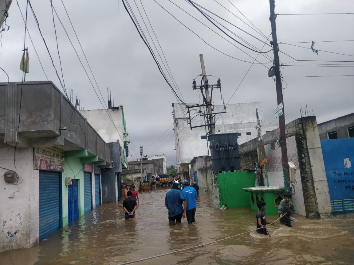
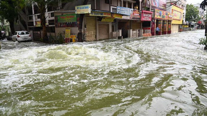
Cars float aimlessly in flooded streets. Waters gush down residential areas. Posh houses slosh with waist deep water and floating furniture. Residents rescue each other using ropes. These are some of the scary visuals coming in from Hyderabad city in Telangana, which has seen incessant rainfall in the last three days.
Heavy rainfall has pounded both Telangana and Andhra Pradesh states on the east coast of south India where at least 30 people have died in rain-related incidents. In Hyderabad city alone, nine people, including a two-month old baby, died after a compound wall collapsed due to heavy rains. In wake of the floods, the Telangana government announced a two-day holiday for all private institutions/offices/non-essential services on October 14 and October 15.
The reason behind very heavy rainfall in these southern states is the deep depression in the Bay of Bengal, which the India Meteorological Department (IMD) had forecasted earlier this month. “A fresh low pressure area is very likely to form over north Andaman Sea & adjoining east central Bay of Bengal around 9 October 2020. It is very likely to move north-westwards towards north Andhra Pradesh and Odisha coasts with gradual intensification into a depression during subsequent 2-3 days,” is what the IMD had warned on October 4. Thereafter, the met department was issuing daily updates on this weather system, which has now thrown life out of gear in Telangana and Andhra Pradesh.
A grim forecast
“October-November is a season of cyclogenesis. The deep depression was formed over the Bay of Bengal and its intensity was maximum across Telangana and Andhra Pradesh, which is why cities across these states have received heavy rainfall. Its intensity will go down as the depression moves towards the western side,” Mahesh Palawat, vice president (meteorology and climate change), Skymet Weather, a private weather forecasting agency, told Gaon Connection.

Meanwhile, the action is now shifting to the west coast of the country where Maharashtra, Goa and Karnataka have already been put on alert.
As per the IMD’s latest update issued at 0820 hours on October 15, “The well marked low pressure area over south Madhya Maharashtra & neighbourhood moved westwards and lay over south Madhya Maharashtra & adjoining south Konkan.It is very likely to move west-northwestwards and emerge into east-central Arabian Sea off Maharashtra coast and concentrate into a Depression over east-central & adjoining northeast Arabian Sea off Maharashtra – south Gujarat coasts during next 48 hours. It is very likely to move gradually west-northwestwards and intensify further.”
Hence, after the east coast of peninsular India, it is time for the west coast to get pounded. Reports of localities in Pune getting flooded due to heavy rainfall have started to pour in.
The IMD has warned “light to moderate rainfall at most places with heavy to very heavy falls at isolated places would occur over Konkan & Goa and adjoining Ghat areas of Madhya Maharashtra and heavy falls at isolated places over coastal Districts of south Gujarat.”
Explaining the reason for the low pressure area to again intensify into a depression as it moves westwards and emerges in the Arabian Sea, Sridhar Balasubramanian, associate professor of mechanical engineering and an adjunct faculty member at IDP Climate Studies at the Indian Institute of Technology Bombay told Gaon Connection: “The reason it will intensify into depression once it crosses Mumbai and enters Arabian Sea is due to abnormally high sea surface temperature of 29-30 degree Celsius. Arabian Sea warming is causing more extremes.”
Record-breaking heavy rainfall
The rainfall data of the IMD shows that in the initial first week of October, Telangana had deficient rainfall. Thereafter, it received very heavy rainfall in the past few days leading to flash floods.
As per the meteorological subdivision-wise rainfall data of the met department, in the first week of this month, between October 1 and October 7, Telangana had large deficient rainfall of minus 64 per cent. As against a normal weekly rainfall of 33.6mm (between Oct 1-7), the meteorological subdivision received 11.9mm rainfall only (see map: Sub-division rainfall Oct 1-7, 2020. Telangana in ‘large deficient’ category). However, this was followed by heavy rainfall in the past few days due to the depression in the Bay of Bengal.
Map: Sub-division rainfall Oct 1-7, 2020. Telangana was in ‘large deficient’ category.
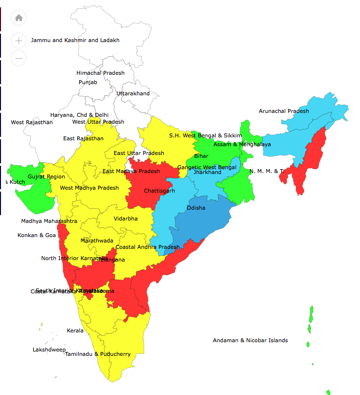
On the single day of October 14, all the 33 districts of Telangana received ‘large excess’ rainfall. And the state recorded a rainfall departure of 2,820 per cent above normal rainfall, as it received 52.6mm rainfall against a normal of 1.8mm.
On the same day, Hyderabad district received 187.2 mm rainfall and recorded a rainfall departure of 6,586 per cent above its normal rainfall. Meanwhile, Malkajgiri, Nalgonda and Warangal Urban districts of Telangana received 8,900 per cent, 4,957 per cent and 7,530 per cent above normal rainfall, respectively.
In the neighbouring state’s coastal Andhra Pradesh meteorological subdivision, rainfall departure of 1,646 per cent above normal rainfall was recorded on October 13, followed by a rainfall departure of 472 per cent on October 14.
Overall, between October 1 and October 14, of the total 33 districts in Telangana, 28 districts have received ‘large excess’ rainfall and three have received ‘excess’ rainfall.
So far, in the month of October (October 1-14), Telangana has received 145 per cent above its normal rainfall, thus coming into the ‘large excess’ rainfall category. Meanwhile, in the same period, the state capital Hyderabad has recorded a rainfall departure of 404 per cent above normal, thus also falling into the category of ‘large excess’ rainfall.
Map: Subdivision wise cumulative rainfall (Oct 1-14, 2020). Telangana now in ‘large excess’ category

Predictably, heavy rainfall has led to floods in Telangana, as people have lost lives and their belongings. Thirty-nine-year-old Naveen Kumar, a resident of Gandhinagar area in Hyderabad considers himself lucky as heavy rainfall induced flash floods spared his locality. But his brother, who owns a printing press in Narayanguda, has lost all his life’s earnings, as his printing press is submerged in the flood waters and all the machinery spoiled. “My brother has suffered a loss of at least four to five lakh rupees,” Kumar told Gaon Connection.
India: Third most disaster-prone
A recent report by the United Nations Office for Disaster Risk Reduction (UNDRR) titled ‘Human Cost of Disasters’ has ranked India number three, after China and the US, in recording the highest number of natural disasters over the last two decades (2000-2019). In this period, China recorded 577 extreme weather events followed by the US at 467 reported events and India at 321 events.
As per this report released on October 13, the International Day for Disaster Risk Reduction, “in the period 2000 to 2019, there were 7,348 major recorded disaster events claiming 1.23 million lives, affecting 4.2 billion people (many on more than one occasion) resulting in approximately US$2.97 trillion in global economic losses.”

This is a sharp increase over the previous twenty years. Between 1980 and 1999, 4,212 disasters were linked to natural hazards worldwide claiming approximately 1.19 million lives and affecting 3.25 billion people resulting in approximately US$1.63 trillion in economic losses.
The report goes on to note that “much of the difference is explained by a rise in climate-related disasters including extreme weather events: from 3,656 climate-related events (1980-1999) to 6,681 climate-related disasters in the period 2000-2019.”
Another 2o17 study by Roxy Mathew Koll and his team at Pune-based Indian Institute of Tropical Meteorology has recorded that “widespread extreme rain events” across central India have tripled between 1950 and 2015 (see Map: Widespread extreme rain events on the rise in central India). Floods attributed to extreme rain events in India alone accounted to losses of about US$ three billion per year, which is 10 per cent of the global economic losses, notes the study. It goes on to inform that there have been 268 reported flooding events in India between 1950 and 2015 affecting about 825 million people, leaving 17 million homeless and killing about 69,000 people.
Map: Widespread extreme rain events on the rise in central India

Source: http://www.rocksea.org/bin/research/roxy_monsoon_extreme_rainfall_nature_2017.pdf
“The rise in extreme rainfall events is over a region where the total monsoon rainfall is decreasing. The fact that this intensification is against the background of a declining monsoon rainfall makes it catastrophic, as it puts several millions of lives, property and agriculture at risk,” warn the authors of the study.
The writing is on the wall. Climate scientists have also issued ample warnings of rise in extreme rainfall events. The government and authorities must act beyond just blaming Nature or climate change for increasing floods and loss of lives and property in the country.
With inputs from Animesh Mishra.

