Dehradun, Uttarakhand
More than seven years after the deadly 2013 floods in the state that killed more than 5,000 people, on January 15 this year Uttarakhand got its first doppler weather radar. This radar, now functional at Mukhteshwar, about 300 kilometres from the state capital Dehradun, will help forecast weather and predict extreme weather events, such as the 2013 cloud burst that led to unprecedented floods in the Himalayan state.
“The doppler radar will help predict the intensity of a weather event and brewing storms in the region well in advance,” Bikram Singh, director of India Meteorological Department’s Dehradun office, told Gaon Connection.
The events of high intensity rainfall followed by rising incidences of cloud burst is the reason why the state has taken a step to set up a doppler radar, said Trivendra Singh Rawat, chief minister of Uttarakhand.
The Mukhteshwar radar, developed indigenously, was inaugurated on January 15 during the IMD’s 146th foundation day celebrations. Two more doppler weather radars are expected to be installed in the state; one at Dhanoulti in Tehri district and another at Lansdowne in Pauri Garhwal. These three doppler radars are being set up in the hill state under the Integrated Himalayan Meteorology programme of the Union ministry of earth sciences.
Doppler Weather Radar at Mukteshwar, Uttarakhand inaugurated by Dr. @drharshvardhan , Hon’ble Union Minister for Earth Sciences, Science & Technology and Health & Family Welfare in the presence of Shri @tsrawatbjp , Hon’ble Chief Minister of Uttarakhand. pic.twitter.com/aXnC1BR1JB
— India Meteorological Department (@Indiametdept) January 15, 2021
This much awaited weather prediction facility, now operational at Mukteshwar, was announced a year after the state witnessed devastating floods in 2013 triggered by a cloud burst. Cloud bursts are extreme weather events in which an area registers more than 100 mm rain in one hour. Massive flash floods swept away villages and everything else that came in their way. While thousands died with dead bodies lying unattended, several hundred are still ‘missing’.
“In monsoon season, cloud bursts are frequent, and it is very difficult to tell the exact location on the day of the weather event. But with an early warning system and real-time monitoring, the intensity can be known,” said Singh.
India has one of the best weather forecasting systems.@Indiametdept has made giant strides in recent years to emerge as one of the foremost meteorological agencies across the world.
— Dr Harsh Vardhan (@drharshvardhan) January 15, 2021
I was delighted to be a part of their 146th Foundation Day Celebrations, today.@moesgoi pic.twitter.com/NtQsptmA0f
Doppler radars for the hills
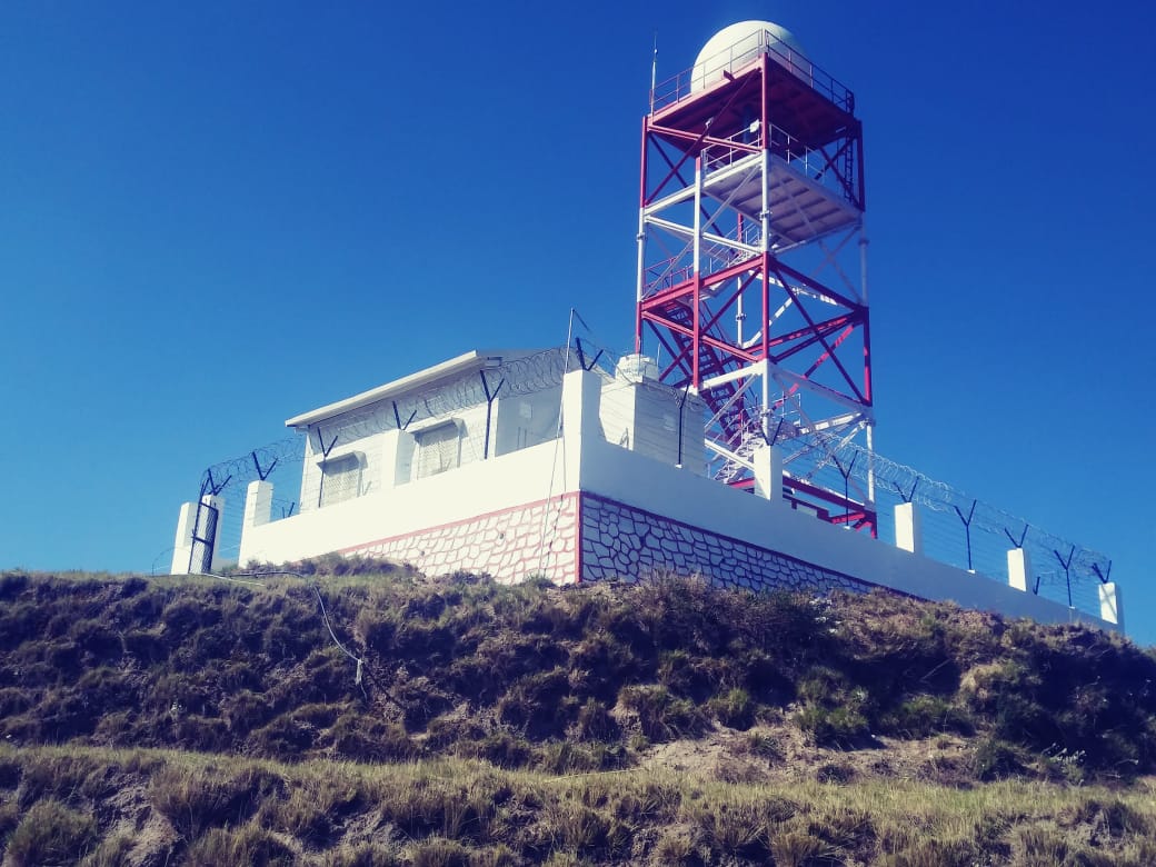
There are three types of radars: X-band, C-band, and S-band. The one installed in the premises of Central Institute of Temperate Horticulture, Mukhteshwar, 51 kilometres off the lake city of Nainital, is a dual polarised X-band doppler radar. The other two radars coming up in Tehri and Pauri Garhwal districts are also X-band radars.
These radars are used primarily for storm detection. They can generate data in real-time at an angle of 360 degrees covering 100 kilometres. This is a dual polarised radar which can pick up the precipitation type — snow, hail, water content and intensity of rainfall.
The data generated from the doppler radar provides information such as wind speed, intensity of rain, etc. for weather events that may occur in the region in the next half-an-hour to three hours in advance.
“The radar transmits a focussed pulse of microwave energy into the atmosphere, a part of this beam when comes in contact with precipitation bounces back. This bounced beam is caught by the radar and measured,” Singh explained to Gaon Connection.
The radar installed at Mukteshwar, costing Rs 10 crore, has been built indigenously by Hyderabad-based Astra Microwave Products Ltd. For the next 10 years, the firm will be responsible for providing timely assistance, both technical and hardware, including its overall maintenance.
Under the Himalayan Meteorology project , India Meteorological Department established a dual polarised, X-Band Doppler Weather Radar at MUKTESHWAR. This radar will help in detection of severe weather over the Uttarakhand. pic.twitter.com/qczpoaoGwm
— India Meteorological Department (@Indiametdept) January 15, 2021
The real time data (GIS) generated by the radar will be available online for the disaster management authorities to access, who will then have to alert the community residing in area to evacuate or not travel during the specified time.
“But any such tool can only be useful when the warning system is coordinated. For example, during the 2013 floods, the prediction of an intensive rain spell was predicted but in an absence of outreach channels, the message could not be communicated to the community,” Anand Sharma, additional director general of IMD Delhi told Gaon Connection.
“Without community participation even location-specific information or an early warning system may not be useful,” said Singh.
New addition to Radar Network of India Meteorological Department on its 146th Foundation Day:
— India Meteorological Department (@Indiametdept) January 15, 2021
India Meteorological Department enhances the observational DWR (Doppler Weather radar) network by adding two more Indigenous radars in the Himalayan Region. 1/2 pic.twitter.com/D5bfCLhhjv
Work is already underway to instal two more radars in a phased manner in the hill state. “We are currently working on the next installation on Surkanda hills located in Dhanaulti, Tehri district,” informed Singh. “It may take some time because there is no paved road to reach the location. A ropeway is underway which in the coming months may help expedite the process,” he added.
The radar in Surkanda will gather data for Garhwal region covering the Chardham and areas around it. If necessary, we may install small radars of the range 10-15 kms in Badrinath based on the performance of the doppler radar, said Singh.
The third radar planned in Lansdowne in Pauri Garhwal is under the military cantonment. An NOC (No-Objection Certification) is pending to acquire the land for building the facility.