Akhari (Sitapur), Uttar Pradesh
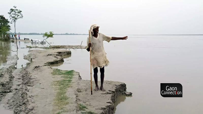
Sitting on the edge of the eroded land in his village, 65-year-old Shankar, a native of Akhari in Sitapur district, gazed pensively at the rising waters of the Ghaghra. The river, which is flowing at severe flood level in Uttar Pradesh, has marooned Shankar’s village and washed away fertile agricultural lands.
“The river’s taken away my land, all I am left with is my house and I’m not sure as to how long it will last. Seeing the river’s fury this year, the future seems really bleak,” Shankar, a marginal farmer who owned half an acre (0.2 hectares) of washed away land, told Gaon Connection.
When asked if he was not afraid of sitting so close to the rising river, he said nonchalantly: “Kaahe ka dar, jab nadi apne pe aayegi to sab kaat le jayegi”. (I have no fears left, if the river has to take me, my lands along, it will)
Shankar’s village is situated about 80 kilometers from the state capital Lucknow. Like his village Akhari, over 500 villages in 24 districts of Uttar Pradesh are facing floods as several rivers, such as Ganga, Yamuna, Ghaghra, Sharda, Chambal and Sindh continue to flood at high flood levels.
Ghaghra river (known as Sarayu in Ayodhya) , which is a tributary of the Ganga, is known to bring floods to the Sitapur district but the destruction caused this year is unprecedented, inform the villagers. Most of the residents of the Akhari village have migrated to nearby villages that are relatively better to live in.
Also Read: Known predominantly for droughts, why are districts in south Bihar facing floods?
“Last year the river used to flow 500 metres north of this village, but now it’s flowing right on the periphery of the village,” 35-year-old Brajesh Tiwari, a resident of the same village, told Gaon Connection.
“Many villages have entirely disappeared into the river. The erosion of land has been happening for many years but this year it’s enormous. A few kilometres away from here, two villages — Paramgauda and Kanchanapur — were facing heavy erosion every year, but this year they have lost their existence completely,” he added.
Brajesh Tiwari feared that his village would also be lost to the river if check dams and embankments were not constructed urgently.
Floods, erosion and migration
Anil Tiwari’s house in Akhari village has survived the onslaught of the flood water so far. The 50-year-old is the sole resident in his house as his sons have migrated to Lucknow where they work as labourers and live in a rented accommodation.
“I used to have dus bigha of agricultural land (about a hectare) but the river consumed it all. Nothing is left to do here and I have sent my sons to work in the city so that they can make a living,” Anil Tiwari told Gaon Connection.
“It is indeed scary but there’s nowhere to go at this age. I’ll die on the same land where I was born, we had demanded alternate lands to be allotted to us but the government has done nothing so far,” he added.
Villages wiped off
About four kilometers away from Akhari, the Angrora village is completely engulfed by the Ghaghra river. Its residents have migrated to other villages.
One such erstwhile resident of the Angora village is 50-year-old Gayatri who has now migrated to the neighbouring Harpalpurwa village.
“The flood here comes every year but the damage is huge this year. My grains and fodder kept in the stores have all spoiled. I had no option but to shift to this village,” she told Gaon Connection.
Meanwhile, Vishal Porwal, executive engineer of Sharda-Ghaghra canal section in state’s Irrigation Department in Sitapur, told Gaon Connection that all the projects of the department are presently safe from the floods.
“Action is being taken at the Akhari-Angora villages in the Rampur Mathura block. We are placing sandbags in these areas to check the erosion of land and the process is underway to remove the silt in the area,” Porwal said.
Also Read: UP floods ground report: 406 villages inundated in Mirzapur as Ganga flows above danger mark
“Ganga and Yamuna don’t cause such erosion but rivers like Ghaghra and Sharda have a tendency to change their courses and erode lands. In the last twenty to twenty five years, the rivers must have changed their courses by many kilometres,” the executive engineer added.
Flood alert for Ghaghra-Sharda
According to the Central Water Commission (CWC), under the Ministry of Jal Shakti, the Ghaghra river is 1,080 kilometres long. It originates in Himalayan mountains in Tibet and passes through Nepal before reaching the northern plains.
The Sharda river originates in the Kalapani area of Uttarakhand and flows along the western border of Nepal before reaching the area around Sitapur. It is 546.6 kilometers long and 223 kilometers of it flows in India.
As per the CWC’s executive engineer of the middle-Ganga division, from June 1 to August 20 this year, which consisted of 81 days, the Elgin bridge in Barabanki was on alert for 54 days as Ghaghra was flowing above the danger mark.
“It wasn’t the case last year as the water flowed above the danger mark for 60 days in 2020. But due to the river Rapti joining Ghaghra, the water levels are soaring very high this year. At Turtipar (Ballia district), the water level was above the danger mark for 51 days as compared to 24 days last year,” Ashish Awasthi told Gaon Connection.
Govt’s measures to help affected population
In a bid to safeguard the villagers from the floods that affect these areas every year, a 54 kilometre long dam (embankment along the river’s flow) was constructed from Chalari ghat (Bahraich) to Barabanki’s Elgin bridge in 2016.
A total of 58 villages in Sitapur and a total of 250 villages across the districts of Bahraich and Barabanki have been ‘protected’ from the floods by the construction of the dam, claim government officials.
But 20 villages that are situated inside the embankments in the Mehmoodabad tehsil of Sitapur face heavy flooding every year. The villagers here demand to be relocated to safer areas.
Gaon Connection talked to the Revenue Department’s lekhpal for the affected area who informed that a list of people has been released by the additional district magistrate.
“These people have to be rehabilitated in safer areas. I don’t know the details about when it will happen as it is all done by the higher officials,” lekhpal Nripendra Yadav said.
As per him, Rs 95,100 are allotted to people who lose their pucca house to floods whereas Rs 4,100 is for losing the hut.
“Rs 37,500 are also given as compensation for losing a hectare of agricultural land whereas crop loss is compensated with Rs 13,500 per hectare of land,” Yadav informed Gaon Connection.
“The floods came in June while most of the farmers had reaped their mentha (mint) crops by May. Paddy wasn’t planted by the time floods hit the area,” said the lehkpal.
Also Read: No chill for peppermint farmers as rainfall damages crop in Uttar Pradesh
But villagers disagree and informed Gaon Connection that they have suffered huge crop losses due to the floods this year.
As per 60-year-old Badlu from Harpalpurwa village, he lost his mint crop to floods in June. “My field was ready to be harvested in June. But the floods ruined it and nothing is left. I have little hope for compensation,” he said.


