

Explained: How IIT-Bombay’s ‘WebFRIS’ is expected to mitigate destruction caused by floods
Researchers from IIT-Bombay have come up with an easy to use web portal that can potentially help in informed policy making in mitigating the disastrous effects of floods on the vulnerable communities. More details here.

The WebFRIS technology works on two components of floods — hazard and vulnerability.
In a bid to enhance the preparedness of the local communities as well as to provide easily accessible ground level data for the disaster management authorities, the researchers from the Indian Institute of Technology Bombay (IIT-B) have developed Web Flood Risk Information System (WebFRIS) – a flood risk information system which focuses on providing socio-economic vulnerability analysis.
“WebFRIS interface—a first-of-its-kind tool to account for geographic variations in socio-economic vulnerability, is accessible and easy-to-use, and holds potential to help local government and citizens save lives and protect livelihoods,” mentions the press statement issued by the IIT-B.
The technology’s research paper titled ‘WebFRIS: An efficient web-based decision support tool to disseminate end-to-end risk information for flood management’ was published in the Journal of Environmental Management on June 15.
Explained: How air pollution affects monsoon rains in India
The WebFRIS is an easy to use web portal that can be accessed on a smartphone or a laptop with internet connectivity. The researchers’ efforts were based on the understanding that the key to flood prevention is obtaining accurate and timely flood risk information.
“WebFRIS is an effective planning tool for environmental management. Using WebFRIS can help make decisions on whether to invest in infrastructure, residential buildings, or farming, and elucidates the anticipated risk of each choice,” said Subhankar Karmakar, who led the study.
Also Read: Known predominantly for droughts, why are districts in south Bihar facing floods?
WebFRIS’ guiding principles — hazard and vulnerability
The WebFRIS technology works on two components of floods — hazard and vulnerability. Hazard accounts for factors like regional rainfall, flood inundation, and weather phenomena such as cyclones, whereas vulnerability includes both physical vulnerability and socio-economic vulnerability.
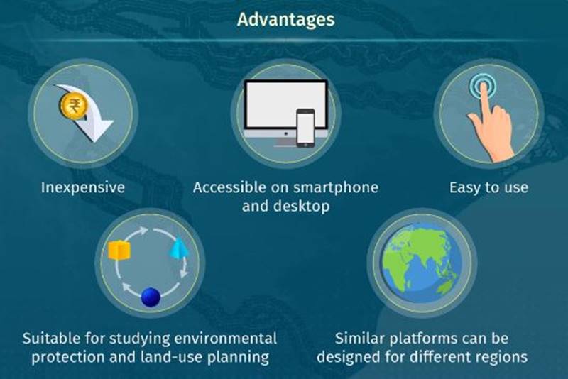
“Web-based platforms are ideal for generating this information because they are inexpensive, reliable, and instantaneously available even in remote areas. However, most existing web-based flood information systems use highly technical jargon that only researchers can understand. This is a major problem in countries with low literacy levels, like India,” the statement mentioned.
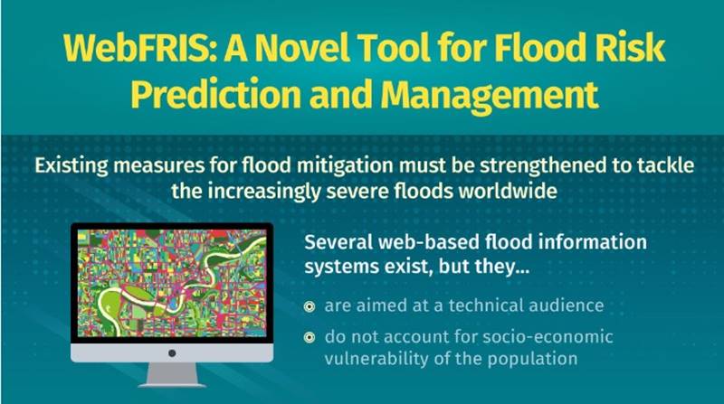
“Furthermore, these portals do not account for socio-economic vulnerability either, a factor that is paramount for infrastructure planning involving rural societies,” it added.
Development of WebFRIS
For the development of WebFRIS, the research team focused on Jagatsinghpur – a district in Odisha. Jagatsinghpur, a part of the Mahanadi River delta, is one the most severely flood-affected regions in the country.
“The lack of on-ground hydrological and meteorological information for risk prediction and modeling in Jagatsinghpur has ensured that, despite a plethora of flood management measures, the district has been unable to combat the impacts of flooding,” it said.
It is informed that the team used mathematical models and statistical data to calculate the flood hazard and vulnerability of the region and quantify flood risk.
“They then designed a web platform to store and visualize all the flood-related data in the form of maps. Finally, to ensure that non-technical audiences could easily understand the data, they translated the measures of flood risk into qualitative information, classifying the risk into color-coded categories from very low to very high,” it explained.
WebFRIS is expected to impart crucial knowledge on flood risk management to local governmental bodies, town planners, flood experts, and even general citizens.
“WebFRIS is an effective planning tool for environmental management. Using WebFRIS can help make decisions on whether to invest in infrastructure, residential buildings, or farming, and elucidates the anticipated risk of each choice,” the project head was quoted.