

Floods 2020: The need for critical engagement with floods in India
This year's monsoon has brought floods to several states of the country. Each region has a different typology of floods and to better respond to them, there is a need to understand the nature of floods.

Eklavya Prasad, Partha Jyoti Das and KJ Joy
The months of July and August this year have again revealed the domination of human induced floods over the naturally occurring floods in India. Rural and urban landscapes in north-eastern, eastern, northern, western and southern India have been ravaged by varied floods resulting in unconventional standard as well as unconventional ramifications. In the eastern, north-eastern and northern parts of the country, the monsoon period is largely referred to as the flood season.
However, since past few years, both the urban and rural spaces in western and southern India also have started experiencing floods on a regular basis, which is a departure from the usual monsoon disposition. Despite the variance, for majority in India, floods get defined by a common definition or are observed as a common occurrence, largely triggered by either the dominant narrative, or because of the dearth of factual explanations. Therefore, there is a need to propel the nuanced realities that surround floods across the country. And to share the legitimate reasons behind floods in diverse landscapes in India, the flood discourse has to be shaped in such a way that it helps in demystifying floods by highlighting the complexities and the nuances.
The monsoon of 2020
As of August 24, Assam, North Bihar, Eastern Uttar Pradesh, Madhya Pradesh, Mumbai, Telangana, Andhra Pradesh, Karnataka, Kerala are either experiencing or have already encountered the destruction caused by floods. Briefs on the present floods will induce questions that seek answers.
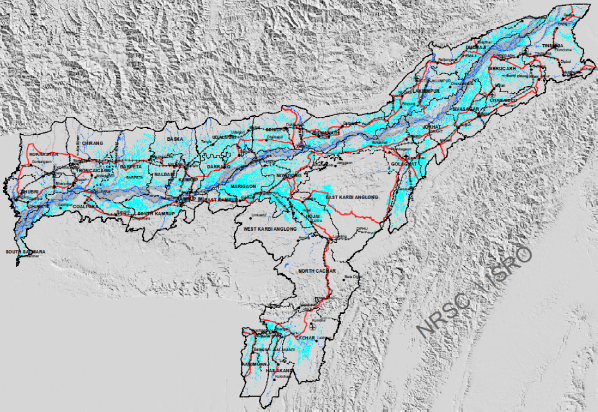
Assam
According to the daily flood update by the Assam State Disaster Management Agency (ASDMA) as on August 24, 2020, 5.69 million people have been affected during the 2020 monsoon in the state of Assam. Flooding in 5,378 villages in 30 of the state’s 33 districts has been reported. Approximately 113 flood-related fatalities were reported from 23 flood affected districts.
From June 1 till August 24, the state has received 1223.60 millimetre (mm) of rainfall. There are 10,063 houses that have been permanently damaged, and approximately 46,490 have been partially impacted. As of now the rest are under assessment. The total cropped area affected by the floods is estimated to be approximately 0.26 million hectares (ha). Assam’s floods also have a transboundary impact as there are about 56 rivers flow from the Bhutan Himalayas through western Assam and about four large rivers such as the Siang (mainstream of the Brahmaputra), Debang, Lohit and Subansiri which flow from Tibetan landscape to eastern Assam, all these river contribute their flows to the flooding of the Brahmaputra while many of these cause floods on their own with major flood generating events occurring outside the country on many occasions.
Map 1- Flood inundation of Assam.
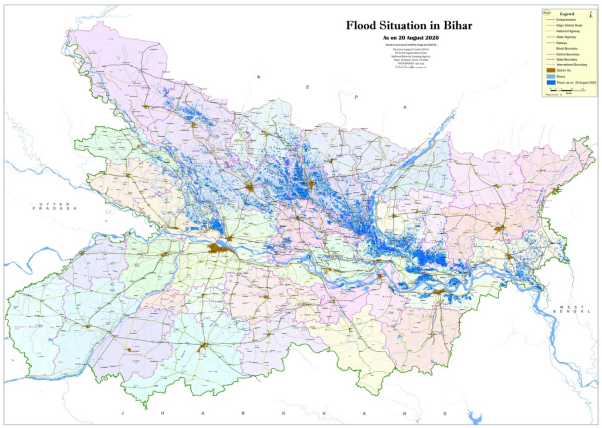
Bihar
Floods have affected Bihar from July 13 onwards this year. By the third week of August, flooding impacted over 8.36 million people across 16 districts, according to the Disaster Management Department (DMD), Government of Bihar. The DMD reported 27 fatalities as a result of flooding. Furthermore, 550,792 people have been evacuated, with almost 5,186 of them now staying in six relief camps.
There are approximately 21 known rivers that have flooded North Bihar, for instance Adhwara Samuh, Lakhandehi, Rato, Marha, Manusmara, Bagmati, Kosi, Mahananda, Kankai, Kamla Balan, Gandak, Sikrana (Bhudi Gandak), Kadane, Noon, Baya, Tilawe, Dhanauti, Masan, Kareh, Ganga, and Dhonas. In addition, there are innumerable unknown small and seasonal rivers across the Nepal-India border that drain the monsoon over the Chure range in Nepal in India (Bihar).
Map 2 – Flood inundation map of Bihar
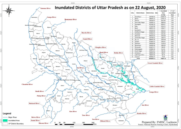
Uttar Pradesh
Recent heavy rains have resulted in the second phase of floods in Uttar Pradesh (UP), affecting 1,090 villages in 16 districts. According to reports Sharda at Palia Kalan (in Lakhimpur Kheri), river Rapti at Shravasti, river Saryu at Elginbridge (in Barabanki), Ayodhya and Turtipar (in Ballia) were flowing above the danger mark. Other flood related details are awaited.
Earlier in the month there were 19 districts affected by floods in UP. Then a total of 582 villages in these districts are affected and 303 of these villages have got marooned. According to reports, Uttar Pradesh has received 10.4 per cent less rainfall between June 1 and August 8, however, four rivers – Ghaghra, Rapti, Sharda and Gandak — crossed the red mark due to 20 per cent excess rainfall in 15 districts of the state’s eastern region, parts of Uttarakhand and the neighbouring country Nepal.
As many as 1,04 562 families and 38,248 hectare of agricultural land have been affected in the 19 flood-hit districts and there are reports of three embankments being damaged in Azamgarh, Mau and Gonda districts.
Map 3 – Flood inundation map of Uttar Pradesh
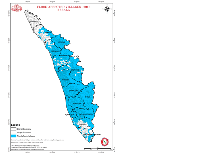
Kerala
Floods, landslides, and landslips following torrential rains have affected Kerala for the third consecutive year. The number of people affected due to flood in 2020 is less compared to 2018 and 2019, where landslides and landslips were rampant in high-range areas of the state. On August 6, a landslide at Pettimudi settlement in Rajamala near Munnar in Idukki district claimed the lives of 52 people while the search is underway to locate 19 more persons who went missing following the devastating landslide. According to reports, Munnar recorded 229mm of rain in 24 hours on August 6. Other areas of the state have experienced heavy rainfall during the same period. Both Peermade and Padinjarathara recorded 297 mm and 276 mm respectively on August 6 and on the following day, Kakkayam received 261 mm followed by 327 mm of rains at Vadakara.
In 2018, the devastating floods and landslides in Kerala affected 5.4 million people, displaced 1.4 million people, and took 433 lives (22 May–29 August 2018). The Post Disaster Need Assessment (PDNA) estimated the total damages to be around INR 105,570 million and total losses to be around INR 161,630 million amounting to a total disaster effect of around INR 267,200million. The Disaster Management Authority of the state reported that Kerala suffered a loss of INR 21,019 million in the 2019 deluge.
Map 4 – Flood affected areas in Kerala (2018)
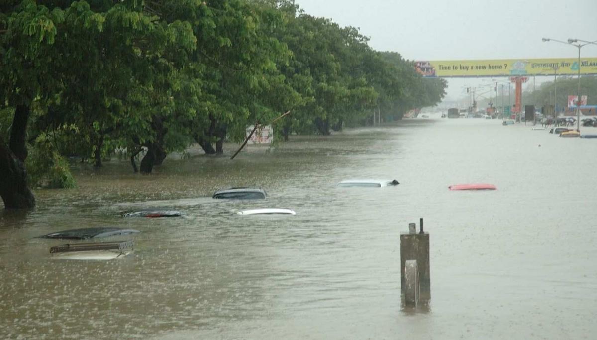
Mumbai city
On August 5, many areas in south Mumbai, which usually do not see waterlogging, were flooded for hours. According to the India Meteorological Department (IMD), in nine hours, its Colaba observatory recorded 225 mm of rainfall. The last time the area had seen heavier rain than Wednesday’s was in 1974. Areas like Churchgate, Marine Drive, Fort, Girgaum, Khetwadi, Walkeshwar Road, J J Marg, Gol Deol, Bhendi Bazaar, Kalbadevi were flooded and water entered several houses.
The amount of rain that Mumbai experiences has remained unchanged over the last 80 years. The old drainage system, along with Mumbai’s then abundant open spaces, allowed the percolation of water and its faster dispersal. The gradual concretisation of open spaces has meant that the percolation of water does not happen the way it used to be. Dereliction of existing drainage system and rampant encroachment of the same are also important factors for enhanced water logging and consequent flooding in Mumbai. On the other hand, three hours of incessant rainfall, recently created havoc in the city of Gurgaon (Gurugram). Vast stretches of the city including seven out of the 11 underpasses in the city were underwater. Various factors like indiscriminate concretization, disappearing water bodies, encroachment on natural drainage systems, unregulated dumping of waste and sewage are some of the reasons being cited for the largescale inundation. However, urban flooding remains an unresolved mystery, requiring comprehension and clarity.
Floods in 2020 across the country have once again highlighted issues requiring attention, deliberations to build a constituency. Therefore there is a need to address the issues, for instituting coherence.
In November 2013, the Forum for Policy Dialogue on Water Conflicts in India (Water Conflicts Forum to be brief) published ‘Agony of Floods: Flood Induced Water Conflicts in India‘, a compendium of 11 case studies from different parts of the country, cutting across geographies and settlements. The rationale behind this publication was to showcase conflicts of varying character and intensity during the times of plenty (floods), as part of the larger effort to understand water conflicts in India.
Therefore, the Water Conflicts Forum with its mandate of capturing, understanding and disseminating knowledge around water based challenges, proposes to initiate interaction between individuals who are intrinsically linked with floods and a wide ranging inquisitive audience wanting to know about floods in India. The interaction will largely highlight floods from a natural phenomenon across history and contemporary perspectives, transformation within river basins and their impact on different landscapes and settlements, gendered experiences of repeated preparation, coping and rehabilitation measures for survival, innovations for minimizing flood triggered challenges, and possible way forward.
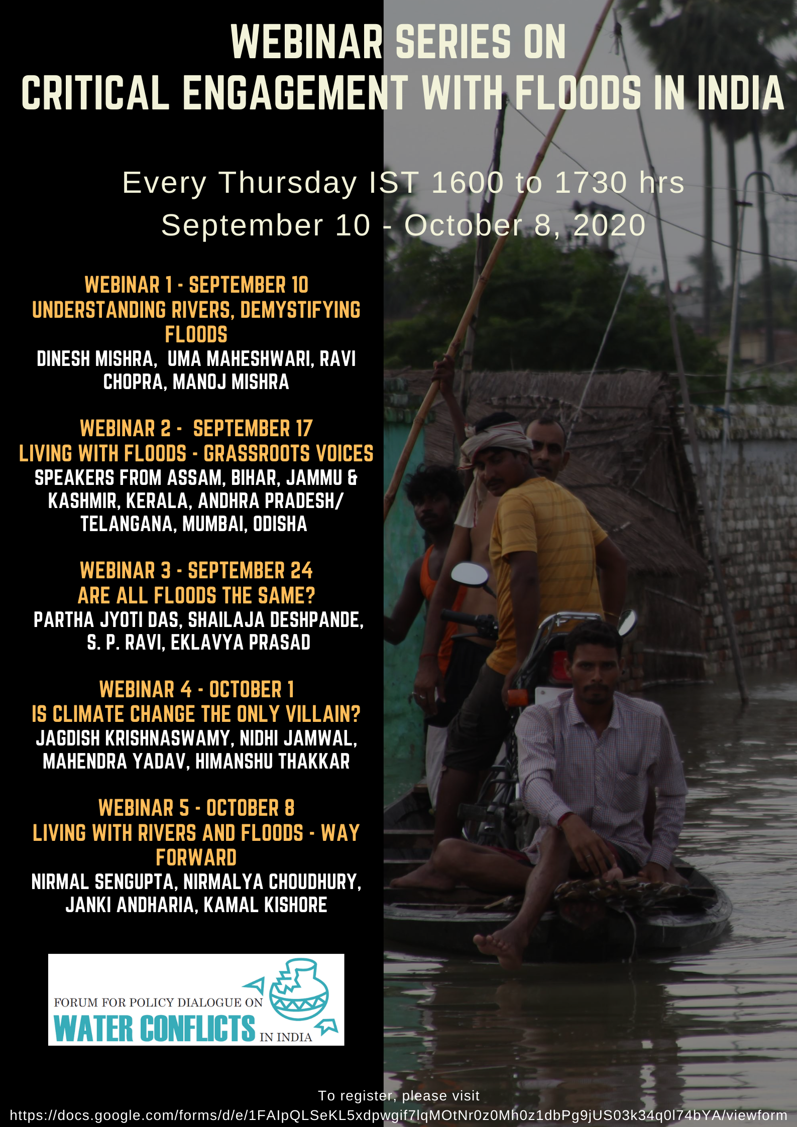
It is with this intention, the Water Conflicts Forum will be organizing a series of webinar over the next one month (September 10 – October 8, 2020) to address various questions related to the floods. These are detailed below:
- Understanding Floods – Historical view of floods in India. Transformed floods, the anthropogenic imprint, reasons and realities, political economy perspective, issue of federal relations between centre and state facilitating or obtruding flood management. Transboundary cooperation in river management for efficient flood risk mitigation in India
- Broad categories and typologies of floods – Across humanscapes in urban, peri-urban and rural areas, highlighting the commonalities and their respective peculiarities. Flood typologies are critical, as preparedness, response and recovery plans and strategies should ideally be determined by the nature and characteristics of flooding (cause, triggering mechanism, amplification and effect), both in the urban and rural spaces.
Therefore, response to floods based on a scientific analysis of flood typology, should be considered a fundamental in any flood management approach. For instance, in North Bihar, Megh Pyne Abhiyan has identified the following eight flood typologies, and that has not only helped in developing a comprehensive understanding of floods in the region, but also presenting the nuances that are often generalized. However, this typology is also applicable to other geographical regions like Assam and Uttar Pradesh. In Assam, floods also occur due to release of water from dams.
- Factors impacting floods – Social, political, economic, ecological, climatic and technical perspectives on floods. Existing policies and strategies concerning flood management
- Effective, sustainable flood risk management and way forward – Gendered experiences, sharing of flood resilient measures–Risk mitigation and adaptive measures across three phases, preparedness, response, recovery and rehabilitation (reconstruction). Way forward as regards flood resilience, adaptation, policy and advocacy
Authors are associated with the Forum for Policy Dialogue on Water Conflicts in India.