

Lack of planned drainage, natural drainage basins encroached. Result: Increased urban flooding in Guwahati
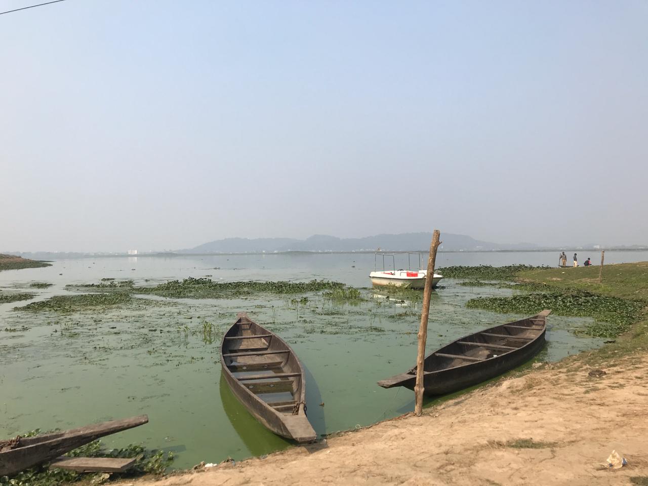
An intricate network of rivers and beels (wetlands) forms the natural drainage system of Guwahati city on the banks of the Brahmaputra river. Last few decades, these water bodies have been encroached upon, thereby contributing towards an increased incidence of urban flooding

Guwahati. Assam
Born and brought up in the Rukmini Nagar area of Guwahati in the northeast India, Amarjyoti Borah has witnessed both the growth of his city and the decay of its water bodies. “In the last three decades, I have seen how the most important water bodies — Deepor Beel, Bahini-Bharalu river and Basistha river — have become sewage channels and dead rivers, which has contributed towards an increased incidence of urban flooding in the city,” Borah told Gaon Connection.
“In the mid-1990s, there was a joke in Guwahati that flooding happens just outside the office of the water resources department in Chandmari, one of the oldest localities in the city,” he said. “But, over the years, urban flooding has increased and newer areas have become prone to this annual problem during the monsoon season when we receive maximum rainfall,” he added.
About five kilometres away from Rukmini Nagar, Zoo Narengi Road in the city is notorious for frequent flooding. “Every time it rains heavily, runoff enters the houses along the road. The local administration keeps raising the height of the road to keep it above the floodwaters. Because of this, the road level is now several feet above the level of houses, leading to latter’s inundation during rainy days,” said Kalyan Das, professor and director-in-charge of Guwahati-based OKD Institute of Social Change and Development, an autonomous research institute of the ICSSR (Indian Council of Social Science Research) and Government of Assam.
“This has forced local people to reconstruct their houses by raising the foundation. House reconstruction is a massive investment [money], which these people could have used for other purposes … People had to take loans to rebuild their houses because of the flooding,” he added.
This problem of urban flooding in Guwahati can be gauged from the fact that in June 2017, four people died in the city when over 2,000 residents were affected due to flash floods.
The location of Guwahati is like a saucer surrounded by hills around it. “Guwahati is like a bowl so when it rains, rainwater gets collected and floods certain areas,” Biswajit Pegu, deputy commissioner of Kamrup Metropolitan district told Gaon Connection. Guwahati is located in this district of Assam. “Also, the city is surrounded by hills, which are being cut leading to landslides and silt clogging the drains and water channels,” he added.
A 2016 research article published in the Journal of Ecosystem & Ecography has documented various hills in the city. “The central part of the city has small hillocks namely Sarania hill (193 m), Nabagrah hill (217 m), Nilanchal hill (193 m) and Chunsali hill (293 m). The Buragosain Parbat in the East and the hills of Rani and Garbhanga in the south form the major hill formations of the city. These hills make contiguous formations with the hills of Meghalaya. There are total of 18 hills in the city,” reads the paper.
Another 2017 report, ‘Estimating sediment and water yield from hills of Guwahati city’, prepared by the Indian Institute of Technology Guwahati, notes: “Sediment yield and high runoff generation from the hilly terrain of Guwahati City is one of the important factors responsible for urban flooding of Guwahati City.”
Because of its location, Guwahati is naturally prone to flash floods because runoff gushes down the hills and reaches the city in no time, said an expert on water and rivers based in Guwahati. “However, the city also has a natural system of rivers and beels to drain the excess water into the Brahmaputra. But, in the last few decades, as the city has expanded, it has eaten into these water bodies and urban flooding has increased,” he added.
Das made a similar point when he informed that paddy fields in and around Guwahati, which used to hold excess rainwater, have now been built over with no room for water to flow.
A July 2014 report ‘Review of Studies on Urban Floods in Guwahati’ prepared by the All India Disaster Mitigation Institute for the Assam State Disaster Management Authority notes the city does not have a planned drainage system. But, it has five broad natural drainage basins. These include Bharalu basin (catchment area of 100 square kilometre), Silsako beel basin (92 sq km), Deepor beel basin (144 sq km), Kalmoni basin (66.5 sq km) and Foreshore basin.
These basins have their own natural channels to carry the excess water. These include the Bharalu-Bahini river system, Mora Bharalu river, Basistha river, Lakhimijan channel, Bondajan channel, Khanajan river and Kalmoni river. All these river systems and channels eventually drain excess water into the Brahmaputra.
However, as the city has urbanised and expanded, it has eaten into these water bodies leading to an increased incidence and intensity of urban flooding.
An August 2018 paper, the ‘Impact Of Urban Growth On Landuse: A Case Study Of Guwahati City, Assam’, published in the International Journal of Engineering Science Invention, has recorded how between 1972 and 2016, the built-up area in the city increased, whereas the open areas, water bodies and forest areas shrunk (see graph: Changing land-use pattern in Guwahati city from 1972 to 2016).
Graph: Changing land-use pattern in Guwahati city from 1972 to 2016
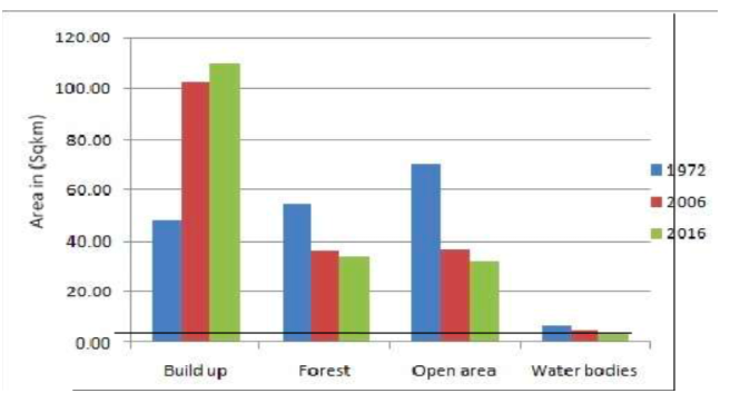
Source: http://www.ijesi.org/papers/Vol(7)i8/Version-2/E0708022632.pdf
Another 2017 research study, ‘Unplanned urban growth: land use/land cover change in the Guwahati Metropolitan Area, India’, has recorded between 1976 and 2015, an area of 51.2 sq km of natural and vegetated areas was converted to built-up area. Another 38.4 sq km of cultivated and managed areas were developed into built-up area (see map: Increase in built-up area in Guwahati).
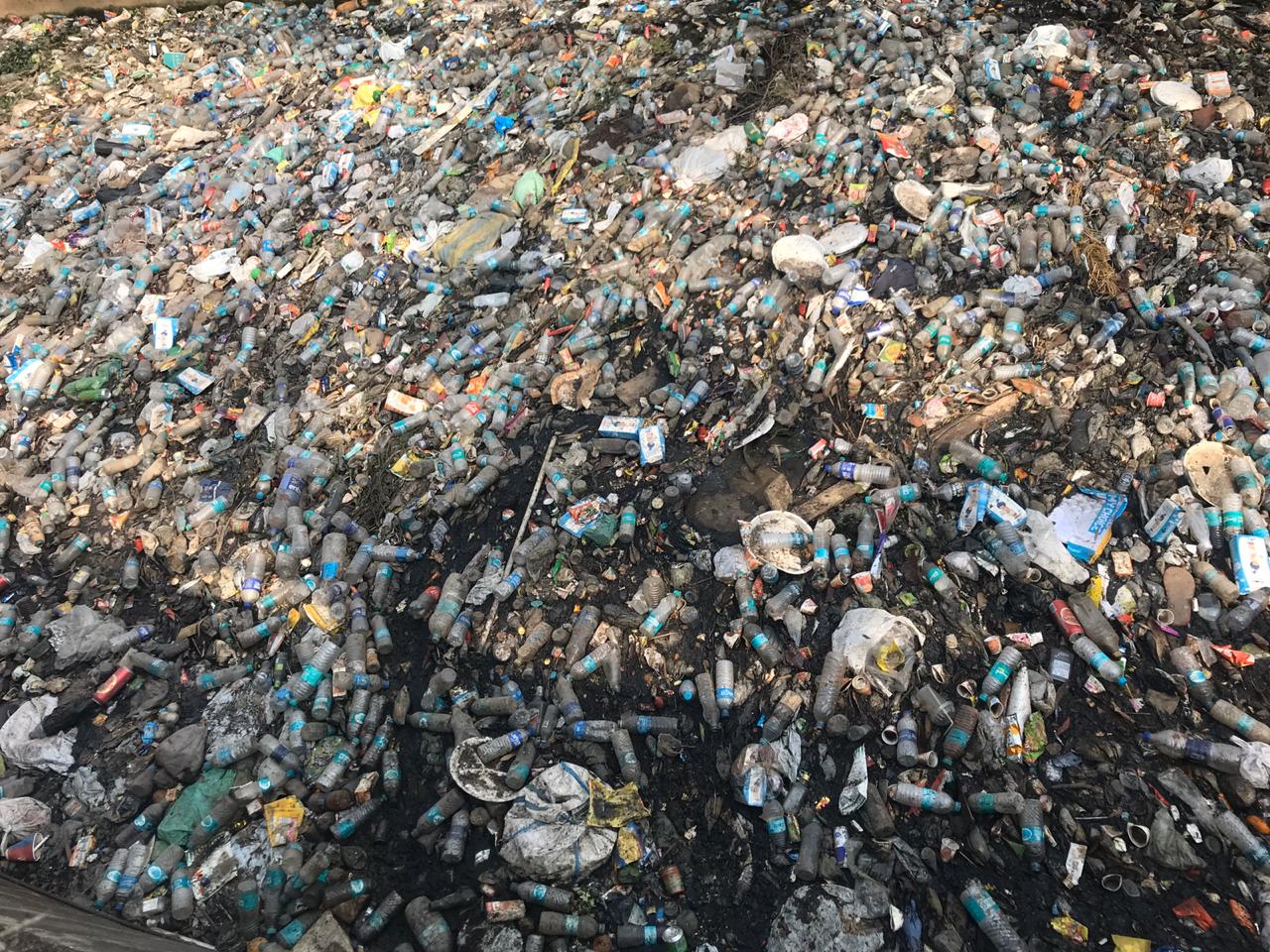
Vaishali Kashyap of the Tata Institute of Social Sciences, Mumbai, has studied two beels in Guwahati — Silsako beel and Bondajan beel — to understand anthropogenic pressures on these two wetlands. In her paper, she has listed four reasons for the slow murder of these beels, which include encroachment, siltation caused due to destruction of the hills, earth-filling, and garbage dumping.
Kashyap noted that before enactment of the Guwahati Waterbodies (Preservation and Conservation) Act 2008, it was the state authorities who “allotted land on the Silsako Beel to various organisations… These include the OKD Institute of Social Change & Development, Institute of Hotel Management, Institute of Cooperative Management, (these three are government institutions), Ginger Hotel (A Tata hotel), All Assam Tennis Association, Assam Sahitya Sabha, etc.”
Meanwhile, the condition of Bondajan beel was found to be worse. She noted the four laning of the existing Guwahati-Chandrapur-Morigaon state highway was eating into this beel.
State officials acknowledge encroachments of the wetlands. “Guwahati had a number of beels, which have slowly shrunk in size. Some has disappeared, too… Bharalu, the main river that drains the city, carries sewage all through the year and cannot take the load of excess rainfall,” said Pegu.
Gaon Connection has reported in detail on how the main Bharalu-Bahini river of Guwahati has turned into a channel of untreated sewage.
Map: Increase in built-up area in Guwahati
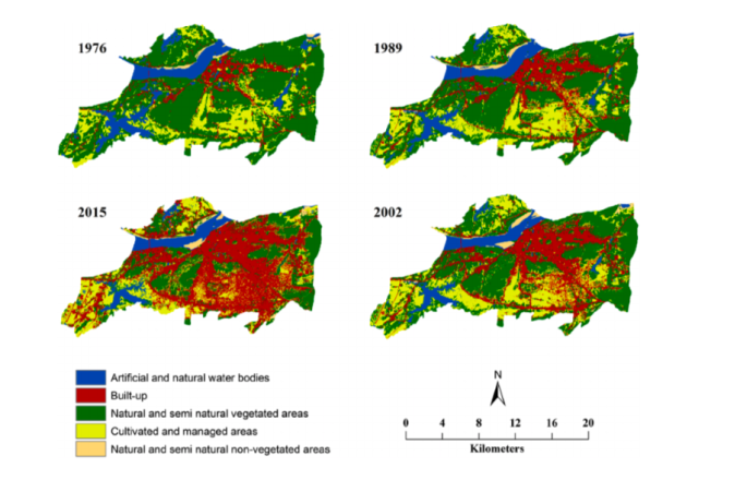
Source: Chandra Kant Pawe and Anup Saikia 2017, ‘Unplanned urban growth: land use/land cover change in the Guwahati Metropolitan Area, India’, https://www.researchgate.net/publication/321311265_Unplanned_urban_growth_land_useland_cover_change_in_the_Guwahati_Metropolitan_Area_India
Based on hydro-meteorological data (rainfall, daily water discharge, etc) and spatial data (municipal ward layout, sewer-storm/drainage maps, etc), the July 2014 report by the All India Disaster Mitigation Institute has prepared flood zone map of Guwahati city (see map: Ward-wise flood zone map of Guwahati city).
It shows more than half of Guwahati Municipal Area — 52.34 per cent — is flood prone. Of this, 16.27 per cent belongs to the chronically inundated category, 13.34 per cent to the occasionally inundated category and 22.73 per cent to the rarely inundated category.
The main factors identified for such a high level of flood risks include “the undulating topography of city with plain area in the middle of city making it prone to flooding, encroachment on natural drain channels and wetlands, lack of proper drainage system and solid waste disposal in the drains and wetlands.”
Map: Ward-wise flood zone map of Guwahati city
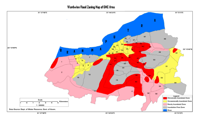
Source: ‘Review of Studies on Urban Floods in Guwahati’, July 2014,All India Disaster Mitigation Institute.
Clearly, the topography of Guwahati makes it naturally prone to floods. However, human activities have added to the city’s vulnerability and added new flood zones in the city. Experts offer both long-term and short-term measures to control urban flooding in the northeastern city. These include drainage master plans, regular desilting and cleaning of water bodies/rivers, regulating hill cutting activities, keeping the rivers free of untreated sewage, etc.
The Directorate of Town and Country Planning, under the Urban Development department of the state government rightly notes: “there is no good planning for drainage network in a single town or city in our state. Due to lack of drainage, areas become water logged and there are several health consequences like malaria, pollution of swallow and ground water etc, and has direct impact on health and hygiene of the locality as well as damage of road, building and other public properties.”
Master drainage plans for various cities in Assam are under preparation. Meanwhile, the Guwahati Development Department of the state government has also launched Mission Flood Free Guwahati, which has four departments — Guwahati Municipal Corporation, Water Resources Department, Guwahati Metropolitan Development Authority, and Public Works Department — working in tandem to mitigate urban flooding in the city.
“Last year we had a campaign to de-silt the drains and clean the beels by involving the local people. Only when our beels are free of encroachment can we handle urban flooding,” said Pegu.
The southwest monsoon 2020 is just a month away. Will Guwahati swim or sink this year?
This story has been published as part of the WaterAid India ‘WASH Matters 2019’ Media Fellowship Program.
Read the first fellowship story here. And, the second story here.