

Uttarakhand: The Himalayan state is besieged by extreme floods and increased droughts
A recent analysis by think tank CEEW India shows a four-fold increase in extreme flood events and two-fold increase in droughts in the past five decades in Uttarakhand. More than 69% of its districts are vulnerable to droughts. Over 50,000 hectares of forest cover have been lost in the last 20 years.

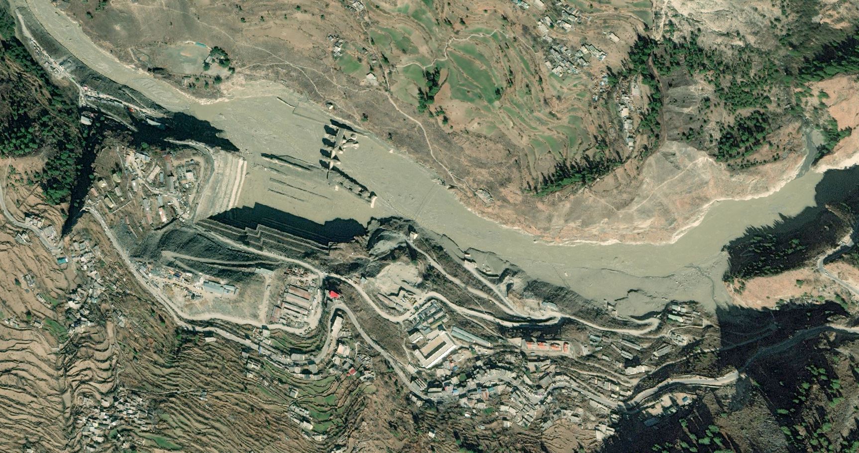
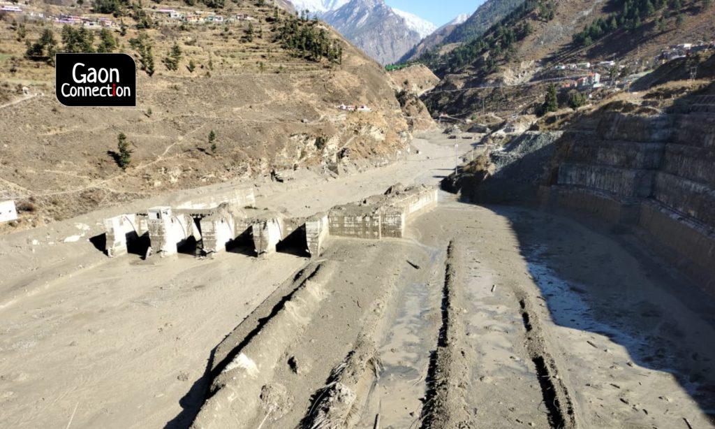
The remains of Tapovan hydropower station following the Uttarakhand Disaster floods, as seen by Maxar's WorldView3 satellite on Feb 10. Source: @WaterSHEDLab/Twitter
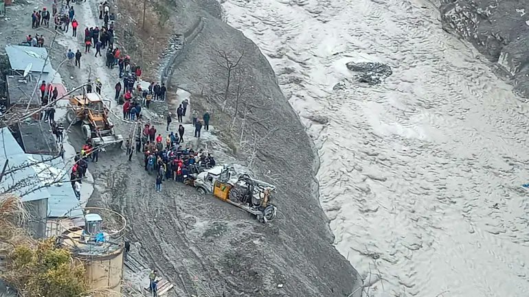
The disaster that struck Chamoli on the morning of February 7, in the form of a landslide and an avalanche, is far from over. At least 55 are dead, of which only 29 have been identified, while over 150 are still missing. The rescue operations are underway.
Meanwhile, satellite imagery analysts have warned about a lake that has formed due to the landslide and is blocking the flow of the Rishi Ganga river. Any breach could lead to another flash flood.
But flash floods aren’t the only disaster the Himalayan state is dealing with. The latest analysis by Council on Energy, Environment and Water (CEEW India), a New Delhi-based think tank, shows how vulnerable Uttarakhand is to climatic changes. The state has recorded an increase in both extreme floods and droughts in the last five decades.
Since 1970, there has been a four-fold increase in extreme flood events in Uttarakhand. A similar increase in associated events such as landslides, cloud bursts and glacial lake outbursts has been recorded. Chamoli, Haridwar, Nainital, Pithoragarh and Uttarkashi districts are most vulnerable to extreme floods.
The analysis by CEEW India found a two-fold increase in droughts in the state during the same period. Over 69 per cent districts in the state are now drought-prone. In the last decade, floods and droughts occurred simultaneously in Almora, Nainital and Pithoragarh districts. This further complicates risk-informed decision-making for policymakers and response teams, said the think tank.
“The recent devastating flash flood in Uttarakhand is further proof that the climate crisis can no longer be ignored,” said Abinash Mohanty, programme lead at CEEW. “In the last twenty years, Uttarakhand has lost more than fifty thousand hectares of forest cover, leading to micro climatic changes in the region. This, in turn, has triggered a rise in extreme climate events in the state,” he added.
Landslide and flash floods
Geologists, glaciologists and satellite imagery analysts are studying what triggered the recent Chamoli disaster and the causes behind it. “So far, what we know is that the landslide did occur and it seems to have fallen directly on the glacier and might have triggered an avalanche in the process… Eventually, the rocks debris and snow started to flow downstream to the Rishi Ganga river and then the Dhauli Ganga river,” Raj Bhagat Palanichamy, GIS and satellite imagery analyst with WRI India, Bengaluru, told Gaon Connection in the Gaon Cafe show.
According to him, the incident [disaster] is not yet over. “The debris is all around. In some places, the riverbed has risen by several metres. The debris has also formed a blockage at the confluence of Ronti ghat and Rishi Ganga river, leading to the formation of an artificial lake,” he said.
He went on to inform that in October 2016, satellite images had picked up a landslide or an avalanche at the same place, and there was debris flow too. “Whether these events are natural or caused due to human influence is a matter of future research. But, for sure, we know that this is an extremely vulnerable area,” he added.
Meanwhile, on February 12, the state disaster response force (SDRF) team reached the artificial lake that has formed upstream of Reni village, near Tapovan. The lake appears to be around 350 meters long, and as per the officials, water is getting discharged and it does not pose any immediate risk.
Climate vulnerability in Uttarakhand
On June 19 last year, the Union Ministry of Earth Sciences released ‘Assessment of Climate Change over the Indian Region’, India’s first climate change assessment report. The report noted that the average temperature in the country has risen by around 0.7 degree Celsius (°C) during 1901-2018 and is projected to rise by approximately 4.4°C by the end of the century. This means an increase in the intensity and frequency of extreme weather events. The rise in temperature is induced due to greenhouse gas emissions, it said.
The report also made some critical observations about the Hindu Kush Himalayan region, which, it said, has experienced a temperature rise of about 1.3°C during 1951-2014. Several of its areas have experienced declining trends in snowfall and retreat of glaciers in recent decades.
By the end of the 21st century, the annual mean surface temperature over the Hindu Kush Himalayas is projected to increase by about 5.2°C. There are projections of an increase in annual precipitation, but a decline in snowfall.
The recent CEEW India analysis also notes that the temperature increase by about 1.3°C in the Hindu Kush Himalayas during 1951–2014 has led to microclimatic changes and faster glacial retreat in the state. It has warned that in the coming years, receding glaciers and flash floods could also impact 32 major ongoing infrastructure projects in the state, worth more than Rs 150 crore each.
“The tragedy in Uttarakhand reiterates the need for detailed district-level climate risk assessments and enhancing adaptive and resilience capacities at various administrative levels. Further, given that vulnerable communities are often the most affected by extreme climate events, they must be made an integral part of risk assessment planning,” said Arunabha Ghosh, Chief Executive Officer, CEEW.
“There is a need to fix accountability in disasters such as the recent Chamoli flash floods in which hydropower projects have been damaged and people killed,” said Himanshu Thakkar, coordinator of South Asia Network on Dams, Rivers and People (SANDRP). “In these areas of the Himalayan region, there should be no hydropower projects, which act as threat multipliers,” he told Gaon Connection.
According to Mohanty, a focus on land use-based forest restoration could not only reverse the climate imbalance but also help promote sustainable tourism in the state. “Equally important would be climate-proofing of infrastructure, investments, and policies. This is no more an option, rather a national imperative to tackle such extreme events and ensure minimal loss and damage,” he said.
The recent flash flood in Uttarakhand is only an example of India’s climate vulnerability. Another CEEW India study published last year found 75 per cent of the country’s districts and over half of the country’s population were vulnerable to extreme climate events. There is a need for a robust plan for climate resilience and adaptation, it said.
With the rising frequency of extreme climate events, India needs to urgently develop a nationwide but decentralised and structured, real-time digital emergency surveillance and management system, said Ghosh. “In the end, we cannot continue with the folly of a business-as-usual development model. This is costing lives, livelihoods and billions in infrastructure damage. India must chart a more resilient and climate-friendly pathway to economic prosperity and human development,” he added.
According to Thakkar, the recent disaster is another wake up call. “It is high time the Indian government reviewed its hydropower policy. The two projects damaged in the Chamoli disaster — Tapovan Vishnugad and Rishi Ganga — should be scrapped immediately. The rest of the under-construction projects should be reviewed,” he said.